
Carte topographique Shropshire Hills National Landscape
Carte interactive
Cliquez sur la carte pour afficher l’altitude.
Shropshire Hills National Landscape
The Shropshire Hills, located in the Welsh Marches, are relatively high: the highest point in the county, Brown Clee Hill, near Ludlow, has an altitude of 540 metres (1,772 ft). This gives Shropshire the 13th highest hill per county in England. Titterstone Clee Hill, part of the Clee Hills, is nearly as high as Brown Clee, at 533 metres (1,749 ft), making it the third highest hill in the county. The Stiperstones are the second highest, at 536 metres (1,759 ft), and are notable for their tors of quartzite; particularly notable are Devil's Chair (SO368991) and Shepherd's Rock (SO373998).
À propos de cette carte
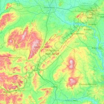
Nom : Carte topographique Shropshire Hills National Landscape, altitude, relief.
Altitude moyenne : 171 m
Altitude minimum : 26 m
Altitude maximum : 530 m
Autres cartes topographiques
Cliquez sur une carte pour visualiser sa topographie, son altitude et son relief.
Minton
United Kingdom > England > Shropshire > Church Stretton > Little Stretton
Altitude moyenne : 272 m
Melverley Green
United Kingdom > England > Shropshire > Melverley > Melverley Green
Altitude moyenne : 60 m