
Carte topographique Kottayam
Carte interactive
Cliquez sur la carte pour afficher l’altitude.
À propos de cette carte
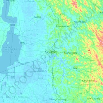
Nom : Carte topographique Kottayam, altitude, relief.
Lieu : Kottayam, Kottayam District, Kerala, 686001, India (9.43156 76.36216 9.75156 76.68216)
Altitude moyenne : 19 m
Altitude minimum : -4 m
Altitude maximum : 157 m
Kottayam has an average elevation of 3 metres (9.8 ft) above sea level. and is situated in the basin of the Meenachil River and in the basin of the Vembanad backwaters, which are formed from several streams in the Western Ghats in Idukki district. According to the division of places in Kerala based on altitudes, Kottayam is classified as being a midland area. The general soil type is alluvial soil. The vegetation is mainly tropical evergreen and moist deciduous type.
Autres cartes topographiques
Cliquez sur une carte pour visualiser sa topographie, son altitude et son relief.
Puthuppally
Puthuppally, Kottayam, Kerala, 686011, India
Altitude moyenne : 18 m
Thiruvanchoor
India > Kerala > Kottayam > Thiruvanchoor
Thiruvanchoor, Kottayam, Kerala, 686637, India
Altitude moyenne : 11 m
Karappuzha Temple Kulam
India > Kerala > Kottayam > Kottayam
Karappuzha Temple Kulam, Kottayam, Kerala, India
Altitude moyenne : 6 m
Mattakkara
India > Kerala > Kottayam > Mattakkara
Mattakkara, Kottayam, Kerala, 686564, India
Altitude moyenne : 41 m