Carte topographique Reno
Carte interactive
Cliquez sur la carte pour afficher l’altitude.
Reno
Reno is characterized by its diverse topography, which is shaped by its elevation and the surrounding mountain ranges. Situated at an average elevation of approximately 4,500 feet (about 1,370 meters), the city is nestled in a high desert region that features a mix of flat valleys and gently rolling hills. To the west, the Sierra Nevada mountains rise dramatically, with peaks often exceeding 10,000 feet (3,048 meters). This mountainous backdrop contributes to a striking contrast against the lower elevations of the city and nearby valleys, such as the Truckee River Valley. The area is also dotted with lakes and parks, providing recreational opportunities amidst its rugged terrain. Overall, Reno's topography combines arid landscapes with stunning mountainous scenery, making it a unique destination for both residents and visitors.
À propos de cette carte

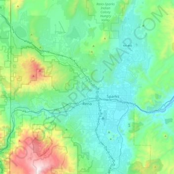
Nom : Carte topographique Reno, altitude, relief.
Lieu : Reno, Washoe County, Nevada, United States (39.39243 -120.00233 39.72344 -119.69935)
Altitude moyenne : 1’650 m
Altitude minimum : 1’316 m
Altitude maximum : 3’010 m
Autres cartes topographiques
Cliquez sur une carte pour visualiser sa topographie, son altitude et son relief.

Oxbow Nature Study Area
United States > Nevada > Washoe County > Reno > West Reno
Altitude moyenne : 1’415 m