
Carte topographique Udaipur
Carte interactive
Cliquez sur la carte pour afficher l’altitude.
À propos de cette carte
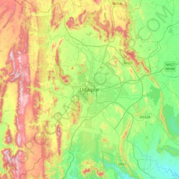
Nom : Carte topographique Udaipur, altitude, relief.
Altitude moyenne : 656 m
Altitude minimum : 408 m
Altitude maximum : 1’067 m
Udaipur is located at 24°31′30″N 73°40′38″E / 24.525049°N 73.677116°E / 24.525049; 73.677116. The city covers an area of 64 km2 (25 sq mi) and lies at an altitude of 598.00 m (1,962 ft) above sea level. It is located in the southern region of Rajasthan, near the Gujarat border. The city lies 403 km (250 mi) southwest of the state capital, Jaipur and 250 km (155 mi) northeast from Ahmedabad.
Autres cartes topographiques
Cliquez sur une carte pour visualiser sa topographie, son altitude et son relief.
Kalarwas
India > Rajasthan > Girwa Tehsil
Kalarwas, Girwa Tehsil, Udaipur District, Rajasthan, India
Altitude moyenne : 583 m
Pratap Park
India > Rajasthan > Girwa Tehsil > Udaipur
Pratap Park, Udaipur, Girwa Tehsil, Udaipur District, Rajasthan, 313001, India
Altitude moyenne : 608 m
Kodiyat
India > Rajasthan > Girwa Tehsil
Kodiyat, Girwa Tehsil, Udaipur District, Rajasthan, India
Altitude moyenne : 672 m