
Carte topographique Woodland Park
Carte interactive
Cliquez sur la carte pour afficher l’altitude.
À propos de cette carte
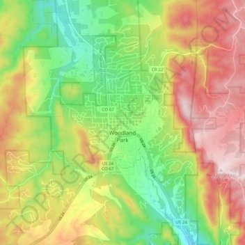
Nom : Carte topographique Woodland Park, altitude, relief.
Altitude moyenne : 2’652 m
Altitude minimum : 2’445 m
Altitude maximum : 2’884 m
The area is characterized by the abundance of large granite rocks and alpine meadows, as well as its consistently high elevation ranging between 8,200 and 10,000 feet above sea level. The climate is considered arid which causes the surrounding forests to become very dry, posing a significant fire threat in combination with a large proportion of lightning strikes and high mountain winds. Fire restrictions are common.
Autres cartes topographiques
Cliquez sur une carte pour visualiser sa topographie, son altitude et son relief.
Victor
United States > Colorado > Teller County
Victor, Teller County, Colorado, United States
Altitude moyenne : 2’974 m
Midland
United States > Colorado > Teller County
Midland, Teller County, Colorado, United States
Altitude moyenne : 2’874 m
Cripple Creek
United States > Colorado > Teller County
Cripple Creek, Teller County, Colorado, United States
Altitude moyenne : 2’946 m
Florissant
United States > Colorado > Teller County
Florissant, Teller County, Colorado, United States
Altitude moyenne : 2’556 m
Divide
United States > Colorado > Teller County
Divide, Teller County, Colorado, United States
Altitude moyenne : 2’796 m
Woodland Park
United States > Colorado > Teller County > Woodland Park
Woodland Park, Teller County, Colorado, 80863, United States
Altitude moyenne : 2’657 m
Copper Mountain
United States > Colorado > Teller County
Copper Mountain, Teller County, Colorado, 80813, United States
Altitude moyenne : 2’946 m
Squaw Mountain
United States > Colorado > Teller County
Squaw Mountain, Teller County, Colorado, 80860, United States
Altitude moyenne : 2’977 m