
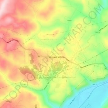
Carte topographique Kingwood
Carte interactive
Cliquez sur la carte pour afficher l’altitude.
À propos de cette carte
Nom : Carte topographique Kingwood, altitude, relief.
Altitude moyenne : 530 m
Altitude minimum : 368 m
Altitude maximum : 679 m
Autres cartes topographiques
Cliquez sur une carte pour visualiser sa topographie, son altitude et son relief.
Horse Shoe Run
United States > West Virginia > Preston County
Horse Shoe Run, Preston County, West Virginia, 26716, United States
Altitude moyenne : 787 m
Rowlesburg
United States > West Virginia > Preston County
Rowlesburg, Preston County, West Virginia, United States
Altitude moyenne : 564 m
Caddell
United States > West Virginia > Preston County
Caddell, Preston County, West Virginia, 26537, United States
Altitude moyenne : 487 m
Terra Alta
United States > West Virginia > Preston County
Terra Alta, Preston County, West Virginia, United States
Altitude moyenne : 775 m
Mount Nebo
United States > West Virginia > Preston County
Mount Nebo, Preston County, West Virginia, United States
Altitude moyenne : 552 m
Aurora
United States > West Virginia > Preston County
Aurora, Preston County, West Virginia, 26705, United States
Altitude moyenne : 812 m
Preston
United States > West Virginia > Preston County
Preston, Preston County, West Virginia, 26537, United States
Altitude moyenne : 502 m
Alpine Lake
United States > West Virginia > Preston County > Alpine Lake
Alpine Lake, Preston County, West Virginia, 26764, United States
Altitude moyenne : 830 m
Eglon
United States > West Virginia > Preston County
Eglon, Preston County, West Virginia, 26716, United States
Altitude moyenne : 816 m
Newburg
United States > West Virginia > Preston County
Newburg, Preston County, West Virginia, 26410, United States
Altitude moyenne : 451 m
Reedsville
United States > West Virginia > Preston County
Reedsville, Preston County, West Virginia, 26547, United States
Altitude moyenne : 535 m
Bruceton Mills
United States > West Virginia > Preston County
Bruceton Mills, Preston County, West Virginia, United States
Altitude moyenne : 508 m