
Carte topographique Amravati
Carte interactive
Cliquez sur la carte pour afficher l’altitude.
À propos de cette carte
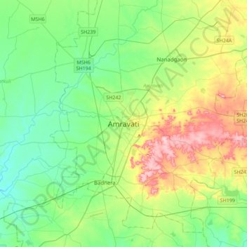
Nom : Carte topographique Amravati, altitude, relief.
Lieu : Amravati, अमरावती, Maharashtra, 444600, India (20.77162 77.59885 21.09162 77.91885)
Altitude moyenne : 345 m
Altitude minimum : 287 m
Altitude maximum : 478 m
Amravati is located at 20°56′N 77°45′E / 20.93°N 77.75°E / 20.93; 77.75. It has an average elevation of 343 metres (1125 feet). It lies 156 km (97 mi) west of Nagpur and serves as the administrative centre of Amravati District and of Amravati Division. The city is located near the passes through the hills that separate the cotton-growing regions of the Purna basin to the West and the Wardha basin to the East. There are two lakes in the eastern part of the city, Chhatri Talao & Wadali Talao. Pohara & Chirodi hills are to the east of the city. The Maltekdi hill is inside the city, it is 60 meters high.
Autres cartes topographiques
Cliquez sur une carte pour visualiser sa topographie, son altitude et son relief.
Pedhi
India > Maharashtra > Amravati
Pedhi, Amravati, अमरावती, Maharashtra, 444600, India
Altitude moyenne : 304 m