
Carte topographique Rhode Island
Carte interactive
Cliquez sur la carte pour afficher l’altitude.
À propos de cette carte
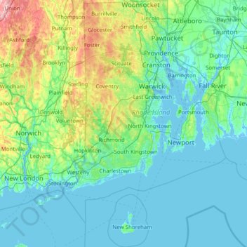
Nom : Carte topographique Rhode Island, altitude, relief.
Lieu : Rhode Island, United States (41.09583 -71.90743 42.01894 -71.08857)
Altitude moyenne : 53 m
Altitude minimum : -8 m
Altitude maximum : 393 m
Rhode Island covers an area of 1,214 square miles (3,144 km2) within the New England region of the Northeastern United States and is bordered on the north and east by Massachusetts, on the west by Connecticut, and on the south by Rhode Island Sound and the Atlantic Ocean. It shares a narrow maritime border with New York State between Block Island and Long Island. The state's mean elevation is 200 feet (61 m). It is only 37 miles (60 km) wide and 48 miles (77 km) long, yet the state has a tidal shoreline on Narragansett Bay and the Atlantic Ocean of 384 miles (618 km).
Autres cartes topographiques
Cliquez sur une carte pour visualiser sa topographie, son altitude et son relief.
Los Angeles
Los Angeles, Los Angeles County, California, United States
Altitude moyenne : 241 m
Brooklyn
United States > New York > New York
Brooklyn, Kings County, New York, United States
Altitude moyenne : 9 m
Spokane
United States > Washington > Spokane County
Spokane, Spokane County, Washington, United States
Altitude moyenne : 655 m
Jacksonville
United States > Florida > Duval County
Jacksonville, Duval County, Florida, United States
Altitude moyenne : 10 m
Sonoma County
Sonoma County, California, United States
Altitude moyenne : 210 m
Madison
United States > Wisconsin > Dane County
Madison, Dane County, Wisconsin, United States
Altitude moyenne : 284 m
Sacramento
United States > California > Sacramento County
Sacramento, Sacramento County, California, United States
Altitude moyenne : 10 m
Hillsborough County
Hillsborough County, Florida, United States
Altitude moyenne : 20 m
Knoxville
United States > Tennessee > Knox County
Knoxville, Knox County, East Tennessee, Tennessee, United States
Altitude moyenne : 307 m
New Orleans
United States > Louisiana > Orleans Parish
New Orleans, Orleans Parish, Louisiana, United States
Altitude moyenne : 1 m
Staten Island
United States > New York > New York
Staten Island, Richmond County, New York, United States
Altitude moyenne : 9 m
Santa Cruz
United States > California > Santa Cruz County
Santa Cruz, Santa Cruz County, California, United States
Altitude moyenne : 89 m
Middle East
United States > Maryland > Baltimore
Middle East, Baltimore, Maryland, United States
Altitude moyenne : 29 m
Everglades National Park
United States > Florida > Monroe County
Everglades National Park, Monroe County, Florida, United States
Altitude moyenne : 2 m
Bergen County
Bergen County, New Jersey, United States
Altitude moyenne : 66 m