
Carte topographique Province of Morropón
Carte interactive
Cliquez sur la carte pour afficher l’altitude.
À propos de cette carte
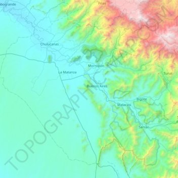
Nom : Carte topographique Province of Morropón, altitude, relief.
Lieu : Province of Morropón, Piura, Peru (-5.63003 -80.36502 -4.92783 -79.64221)
Altitude moyenne : 603 m
Altitude minimum : 60 m
Altitude maximum : 3’662 m
This province is located in the center of the Piura Region, being a land of contrast and climatic fusion. It is dotted by tropical forests of the dry-equatorial style in its flat areas were the carob tree predominates. In high areas of an elevation 1,500 to 2,000 metres (4,900–6,600 ft) the landscape changes to smooth high jungle and a lack of varied hilly valleys.
Autres cartes topographiques
Cliquez sur une carte pour visualiser sa topographie, son altitude et son relief.
Lucarqui
Peru > Piura > Distrito de Ayabaca
Lucarqui, Distrito de Ayabaca, Province of Ayabaca, Piura, Peru
Altitude moyenne : 1’862 m
Parque Miguel Cortés
Parque Miguel Cortés, Urbanización 4 de Enero, Piura, Province of Piura, Piura, Peru
Altitude moyenne : 32 m
Cerro Vicús
Peru > Piura > Chulucanas
Cerro Vicús, Chulucanas, Morropón, Piura, Peru
Altitude moyenne : 171 m
Aypate
Peru > Piura > Distrito de Ayabaca
Aypate, PE-3N, Distrito de Ayabaca, Ayabaca, Piura, Peru
Altitude moyenne : 2’568 m