
Carte topographique Lake Secession
Carte interactive
Cliquez sur la carte pour afficher l’altitude.
À propos de cette carte
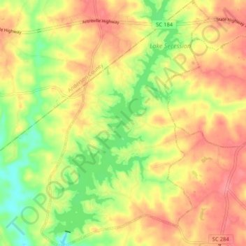
Nom : Carte topographique Lake Secession, altitude, relief.
Altitude moyenne : 188 m
Altitude minimum : 144 m
Altitude maximum : 223 m
Secession Lake is a reservoir on the Rocky River, a tributary of the Savannah River. The spillway elevation is 548 feet (167 m) above sea level. The reservoir extends north into Anderson County, but the CDP consists only of residences built around the lake within Abbeville County. The Antreville CDP borders the Lake Secession CDP to the east.
Autres cartes topographiques
Cliquez sur une carte pour visualiser sa topographie, son altitude et son relief.
Due West
United States > South Carolina > Abbeville County
Due West, Abbeville County, South Carolina, 29639, United States
Altitude moyenne : 202 m
Keowee
United States > South Carolina > Abbeville County
Keowee, Abbeville County, South Carolina, 29656, United States
Altitude moyenne : 214 m