
Carte topographique Uttarakhand
Carte interactive
Cliquez sur la carte pour afficher l’altitude.
À propos de cette carte
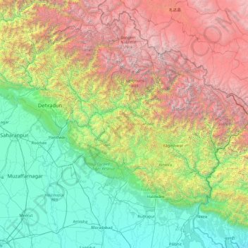
Nom : Carte topographique Uttarakhand, altitude, relief.
Lieu : Uttarakhand, India (28.71579 77.57133 31.45902 81.04479)
Altitude moyenne : 2’102 m
Altitude minimum : 160 m
Altitude maximum : 7’442 m
Uttarakhand lies on the southern slope of the Himalaya range, and the climate and vegetation vary greatly with elevation, from glaciers at the highest elevations to subtropical forests at the lower elevations. The highest elevations are covered by ice and bare rock. Below them, between 3,000 and 5,000 metres (9,800 and 16,400 ft) are the western Himalayan alpine shrub and meadows. The temperate western Himalayan subalpine conifer forests grow just below the tree line. At 3,000 to 2,600 metres (9,800 to 8,500 ft) elevation they transition to the temperate western Himalayan broadleaf forests, which lie in a belt from 2,600 to 1,500 metres (8,500 to 4,900 ft) elevation. Below 1,500 metres (4,900 ft) elevation lie the Himalayan subtropical pine forests. The Upper Gangetic Plains moist deciduous forests and the drier Terai-Duar savanna and grasslands cover the lowlands along the Uttar Pradesh border in a belt locally known as Bhabar. These lowland forests have mostly been cleared for agriculture, but a few pockets remain.
Autres cartes topographiques
Cliquez sur une carte pour visualiser sa topographie, son altitude et son relief.
Bhatwari
Bhatwari, Uttarkashi District, Uttarakhand, India
Altitude moyenne : 4’570 m
Dehradun
India > Uttarakhand > Dehradun
Dehradun, Dehradun District, Uttarakhand, 248001, India
Altitude moyenne : 904 m
Rishikesh
India > Uttarakhand > Rishikesh
Rishikesh, Dehradun, Uttarakhand, 249201, India
Altitude moyenne : 497 m
Gangotri
India > Uttarakhand > Bhatwari
Gangotri, Bhatwari, Uttarkashi District, Uttarakhand, India
Altitude moyenne : 4’139 m
tasila malla
India > Uttarakhand > Satpuli > Ghera
tasila malla, Ghera, Satpuli, Pauri Garhwal District, Uttarakhand, 246129, India
Altitude moyenne : 1’141 m
Purnagiri
Purnagiri, Champawat District, Uttarakhand, India
Altitude moyenne : 638 m
Nainital
India > Uttarakhand > Nainital
Nainital, Nainital District, Uttarakhand, 263003, India
Altitude moyenne : 2’059 m
Nargoli
India > Uttarakhand > Kanda
Nargoli, Kanda, Bageshwar District, Uttarakhand, India
Altitude moyenne : 1’344 m
Lake Vasuki Tal
India > Uttarakhand > Ukhimath > Kedarnath
Lake Vasuki Tal, Kedarnath, Ukhimath, Rudraprayag District, Uttarakhand, India
Altitude moyenne : 4’303 m
Chorabari Glacier
India > Uttarakhand > Ukhimath > Kedarnath
Chorabari Glacier, Kedarnath, Ukhimath, Rudraprayag District, Uttarakhand, India
Altitude moyenne : 5’011 m
Pateliya
India > Uttarakhand > Dhoomakot
Pateliya, Dhoomakot, Pauri Garhwal District, Uttarakhand, 246277, India
Altitude moyenne : 1’857 m
Bhatwari
India > Uttarakhand > Bhatwari
Bhatwari, Uttarkashi, Uttarakhand, India
Altitude moyenne : 2’039 m
Kapkot
India > Uttarakhand > Kapkot
Kapkot, Bageshwar District, Uttarakhand, India
Altitude moyenne : 1’462 m
Joshimath
India > Uttarakhand > Joshimath Tehsil
Joshimath, Joshimath Tehsil, Chamoli District, Uttarakhand, India
Altitude moyenne : 2’272 m
Pundrasu
India > Uttarakhand > Yamkeshwar
Pundrasu, Yamkeshwar, Pauri Garhwal District, Uttarakhand, 249304, India
Altitude moyenne : 862 m
Byasi
India > Uttarakhand > Narendra Nagar
Byasi, Narendra Nagar, Tehri Garhwal District, Uttarakhand, India
Altitude moyenne : 712 m
Atta
India > Uttarakhand > Yamkeshwar
Atta, Yamkeshwar, Pauri Garhwal District, Uttarakhand, 246121, India
Altitude moyenne : 1’004 m
Khera Malla
India > Uttarakhand > Dhanaulti
Khera Malla, Dhanaulti, Tehri Garhwal District, Uttarakhand, 249180, India
Altitude moyenne : 1’657 m
Mohanchatti
India > Uttarakhand > Yamkeshwar
Mohanchatti, Yamkeshwar, Pauri Garhwal District, Uttarakhand, India
Altitude moyenne : 744 m
Mana
India > Uttarakhand > Joshimath Tehsil
Mana, Joshimath Tehsil, Chamoli District, Uttarakhand, India
Altitude moyenne : 4’959 m
Binak
India > Uttarakhand > Yamkeshwar
Binak, Yamkeshwar, Pauri Garhwal District, Uttarakhand, 246121, India
Altitude moyenne : 954 m
Hitoli
India > Uttarakhand > Pauri
Hitoli, Pauri, Pauri Garhwal District, Uttarakhand, 246163, India
Altitude moyenne : 1’384 m
Chopta
India > Uttarakhand > Rudraprayag
Chopta, Rudraprayag, Rudraprayag District, Uttarakhand, 246442, India
Altitude moyenne : 1’414 m
Chopta
India > Uttarakhand > Thailisain
Chopta, Thailisain, Pauri Garhwal District, Uttarakhand, 246275, India
Altitude moyenne : 1’921 m
Devdarshnidhar
India > Uttarakhand > Tehri > Kanatal
Devdarshnidhar, Kanatal, Tehri, Tehri Garhwal District, Uttarakhand, India
Altitude moyenne : 2’152 m
Ratgaon
India > Uttarakhand > Tharali
Ratgaon, Tharali, Chamoli District, Uttarakhand, India
Altitude moyenne : 2’229 m
Pindar
India > Uttarakhand > Tharali
Pindar, Tharali, Chamoli District, Uttarakhand, India
Altitude moyenne : 2’533 m
Nainital
India > Uttarakhand > Nainital
Nainital, Uttarakhand, 263003, India
Altitude moyenne : 1’813 m
Bironkhal
India > Uttarakhand > Thailisain
Bironkhal, Thailisain, Pauri Garhwal District, Uttarakhand, 246276, India
Altitude moyenne : 1’439 m
Chaukhuta
India > Uttarakhand > Dhari > Kasiyalekh
Chaukhuta, Kasiyalekh, Dhari, Nainital District, Uttarakhand, 263132, India
Altitude moyenne : 1’963 m
Masras
India > Uttarakhand > Vikasnagar
Masras, Vikasnagar, Dehradun District, Uttarakhand, India
Altitude moyenne : 1’136 m
Palasi
India > Uttarakhand > Dhoomakot
Palasi, Dhoomakot, Pauri Garhwal District, Uttarakhand, 246279, India
Altitude moyenne : 1’254 m
Bagori
India > Uttarakhand > Bhatwari
Bagori, Bhatwari, Uttarkashi District, Uttarakhand, India
Altitude moyenne : 2’955 m
Saboli Magchyori
India > Uttarakhand > Bhikiasain > Hikyasen
Saboli Magchyori, Hikyasen, Bhikiasain, Almora District, Uttarakhand, 263667, India
Altitude moyenne : 996 m
Khopi
India > Uttarakhand > Nainital > Bhumiyadhar
Khopi, Bhumiyadhar, Nainital, Nainital District, Uttarakhand, 263003, India
Altitude moyenne : 1’656 m
Dādāmandi
India > Uttarakhand > Kotdwara
Dādāmandi, Kotdwara, Pauri Garhwal District, Uttarakhand, 246124, India
Altitude moyenne : 1’032 m
Miyani
India > Uttarakhand > Dhanaulti
Miyani, Dhanaulti, Tehri Garhwal District, Uttarakhand, 249186, India
Altitude moyenne : 1’499 m
Dhalwala park
India > Uttarakhand > Narendra Nagar
Dhalwala park, Dhalwala,Rishikesh,Uttarakhand 249201, Dhalwala, Narendra Nagar, Tehri Garhwal District, Uttarakhand, 249201, India
Altitude moyenne : 390 m
Nakuri
India > Uttarakhand > Garud
Nakuri, Garud, Bageshwar District, Uttarakhand, 263639, India
Altitude moyenne : 1’631 m
Golana
India > Uttarakhand > Syalde
Golana, Syalde, Almora District, Uttarakhand, 263659, India
Altitude moyenne : 1’137 m
Bhujyura
India > Uttarakhand > Bhanoli > Siroda
Bhujyura, Siroda, Bhanoli, Almora District, Uttarakhand, 263624, India
Altitude moyenne : 1’989 m
Taknaur Renge
India > Uttarakhand > Bhatwari
Taknaur Renge, Bhatwari, Uttarkashi District, Uttarakhand, India
Altitude moyenne : 1’811 m
Dangoli
India > Uttarakhand > Garud
Dangoli, Garud, Bageshwar District, Uttarakhand, 263635, India
Altitude moyenne : 1’223 m
Naini Lake
India > Uttarakhand > Nainital > Nainital
Naini Lake, Talllital, Nainital, Nainital District, Uttarakhand, India
Altitude moyenne : 2’057 m