
Carte topographique Kedarnath
Carte interactive
Cliquez sur la carte pour afficher l’altitude.
À propos de cette carte
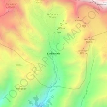
Nom : Carte topographique Kedarnath, altitude, relief.
Lieu : Kedarnath, Ukhimath, Rudraprayag District, Uttarakhand, India (30.69456 79.02732 30.77456 79.10732)
Altitude moyenne : 4’219 m
Altitude minimum : 2’761 m
Altitude maximum : 6’050 m
Autres cartes topographiques
Cliquez sur une carte pour visualiser sa topographie, son altitude et son relief.
Lake Vasuki Tal
India > Uttarakhand > Ukhimath > Kedarnath
Lake Vasuki Tal, Kedarnath, Ukhimath, Rudraprayag District, Uttarakhand, India
Altitude moyenne : 4’303 m
Chorabari Glacier
India > Uttarakhand > Ukhimath > Kedarnath
Chorabari Glacier, Kedarnath, Ukhimath, Rudraprayag District, Uttarakhand, India
Altitude moyenne : 5’011 m
Mansuna
India > Uttarakhand > Ukhimath
Mansuna, Ukhimath, Rudraprayag District, Uttarakhand, 246469, India
Altitude moyenne : 1’653 m
Uthind
India > Uttarakhand > Ukhimath
Uthind, Ukhimath, Rudraprayag District, Uttarakhand, 246419, India
Altitude moyenne : 1’601 m
Khunnu
India > Uttarakhand > Ukhimath
Khunnu, Ukhimath, Rudraprayag District, Uttarakhand, India
Altitude moyenne : 1’841 m
Gaurikund
India > Uttarakhand > Ukhimath
Gaurikund, Ukhimath, Rudraprayag, Uttarakhand, India
Altitude moyenne : 2’589 m
Chopta Chatti
India > Uttarakhand > Ukhimath > Chopta Chatti
Chopta Chatti, Ukhimath, Rudraprayag, Uttarakhand, India
Altitude moyenne : 2’759 m
Sersi
India > Uttarakhand > Ukhimath > Sersi
Sersi, Ukhimath, Rudraprayag, Uttarakhand, 246471, India
Altitude moyenne : 1’942 m
Sonprayag
India > Uttarakhand > Ukhimath
Sonprayag, Ukhimath, Rudraprayag, Uttarakhand, 246471, India
Altitude moyenne : 2’053 m
Guptkashi
India > Uttarakhand > Ukhimath
Guptkashi, Ukhimath, Rudraprayag District, Uttarakhand, 246439, India
Altitude moyenne : 1’449 m