
Carte topographique Roorkee
Carte interactive
Cliquez sur la carte pour afficher l’altitude.
À propos de cette carte
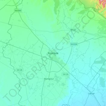
Nom : Carte topographique Roorkee, altitude, relief.
Lieu : Roorkee, Haridwar, Uttarakhand, 247667, India (29.70935 77.73021 30.02935 78.05021)
Altitude moyenne : 270 m
Altitude minimum : 233 m
Altitude maximum : 608 m
Roorkee is located at 29°52′N 77°53′E / 29.87°N 77.88°E / 29.87; 77.88. It has an average elevation of 268 metres (879 ft).
Autres cartes topographiques
Cliquez sur une carte pour visualiser sa topographie, son altitude et son relief.
Jhabrera
India > Uttarakhand > Roorkee
Jhabrera, Roorkee, Haridwar, Uttarakhand, 247665, India
Altitude moyenne : 265 m
Gurunarsa
India > Uttarakhand > Roorkee
Gurunarsa, Roorkee, Haridwar, Uttarakhand, 247670, India
Altitude moyenne : 260 m