
Carte topographique Rishikesh
Carte interactive
Cliquez sur la carte pour afficher l’altitude.
Rishikesh
Rishikesh is at 30°06′12″N 78°17′41″E / 30.103368°N 78.294754°E / 30.103368; 78.294754. It has an average elevation of 372 metres (1,220 ft). The town is located in the Tehri Garhwal region of the northern Indian state of Uttarakhand.
À propos de cette carte
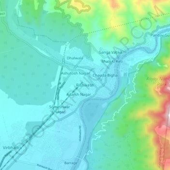
Nom : Carte topographique Rishikesh, altitude, relief.
Lieu : Rishikesh, Dehradun, Uttarakhand, 249201, India (30.06865 78.25162 30.14865 78.33162)
Altitude moyenne : 497 m
Altitude minimum : 323 m
Altitude maximum : 1’363 m