
Carte topographique Dehradun
Carte interactive
Cliquez sur la carte pour afficher l’altitude.
À propos de cette carte
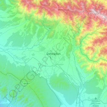
Nom : Carte topographique Dehradun, altitude, relief.
Lieu : Dehradun, Dehradun District, Uttarakhand, 248001, India (30.16556 77.88368 30.48556 78.20368)
Altitude moyenne : 904 m
Altitude minimum : 402 m
Altitude maximum : 2’568 m
The city of Dehradun mainly lies in Doon Valley and is at a varying height from 410 m (1,350 ft) in Clement Town to above 700 m (2,300 ft) at Malsi which is 15 km (9.3 mi) from the city. However, the average elevation is 450 m (1,480 ft) above sea level. Malsi is the starting point of Lesser Himalayan Range that extends to Mussoorie and beyond. Jaunsar-Bawar hills in Dehradun district rises to 3,700 m (12,100 ft) above sea level. The hilly region of Mussoorie goes up to a height of 1,870–2,017 m (6,135–6,617 ft) above sea level. Its geomorphological and meteorological characteristics make it prone to a number of natural hazards. Beside earthquakes, the region is frequently devastated by landslides, cloudbursts, flash-floods, cold waves and hailstorms.
Autres cartes topographiques
Cliquez sur une carte pour visualiser sa topographie, son altitude et son relief.
Rispana pull
India > Uttarakhand > Dehradun > Dehradun
Rispana pull, Dehradun, Dehradun District, Uttarakhand, 248001, India
Altitude moyenne : 641 m
Mohabbewāla
India > Uttarakhand > Dehradun > Dehradun
Mohabbewāla, Dehradun, Dehradun District, Uttarakhand, 248001, India
Altitude moyenne : 626 m
Ogalwāla
India > Uttarakhand > Dehradun > Dehradun
Ogalwāla, Dehradun, Dehradun District, Uttarakhand, 248001, India
Altitude moyenne : 607 m
kolukhet
India > Uttarakhand > Dehradun > salangaon
kolukhet, salangaon, Dehradun, Uttarakhand, 248129, India
Altitude moyenne : 1’186 m
Maldevta
India > Uttarakhand > Dehradun
Maldevta, Dehradun, Dehradun District, Uttarakhand, 248013, India
Altitude moyenne : 850 m
Mussoorie
India > Uttarakhand > Dehradun
Mussoorie, Dehradun, Uttarakhand, 248179, India
Altitude moyenne : 1’594 m
Sahastradhara
India > Uttarakhand > Dehradun
Sahastradhara, Dehradun, Dehradun District, Uttarakhand, 248009, India
Altitude moyenne : 1’100 m
dhanaula
India > Uttarakhand > Dehradun
dhanaula, Dehradun, Uttarakhand, 248013, India
Altitude moyenne : 1’011 m
Nakraunda
India > Uttarakhand > Dehradun > Nakraunda
Nakraunda, Dehradun, Uttarakhand, 248161, India
Altitude moyenne : 592 m
Rāipur
India > Uttarakhand > Dehradun
Rāipur, Dehradun, Uttarakhand, 248008, India
Altitude moyenne : 672 m