
Carte topographique County Clare
Carte interactive
Cliquez sur la carte pour afficher l’altitude.
À propos de cette carte
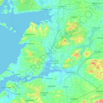
Nom : Carte topographique County Clare, altitude, relief.
Lieu : County Clare, Munster, Irlande (52.55447 -9.93876 53.16891 -8.28242)
Altitude moyenne : 67 m
Altitude minimum : -4 m
Altitude maximum : 862 m
Autres cartes topographiques
Cliquez sur une carte pour visualiser sa topographie, son altitude et son relief.
Killarney
Killarney, Killarney Municipal District, Comté de Kerry, Munster, Irlande
Altitude moyenne : 57 m
Donegal
Donegal, Cobh Rural ED, Municipal District of Cobh, Comté de Cork, Munster, Irlande
Altitude moyenne : 31 m
Poles
Poles, Moynehall ED, Cavan-Belturbet Municipal District, Comté de Cavan, Ulster, Irlande
Altitude moyenne : 112 m
Galway
Irlande > Comté de Limerick > The Municipal District of Adare — Rathkeale
Galway, Iveruss, The Municipal District of Adare — Rathkeale, Comté de Limerick, Munster, Irlande
Altitude moyenne : 17 m
Douglas
Irlande > Comté de Cork > Cork
Douglas, Cork, Comté de Cork, Munster, Irlande
Altitude moyenne : 34 m
Mayo
Mayo, Cootehill Rural ED, Bailieborough-Cootehill Municipal District, Comté de Cavan, Irlande
Altitude moyenne : 132 m
Garland
Garland, Castletown ED, West Cork, Comté de Cork, Munster, Irlande
Altitude moyenne : 140 m
The Municipal District of Bandon – Kinsale
The Municipal District of Bandon – Kinsale, Comté de Cork, Munster, Irlande
Altitude moyenne : 69 m
The Municipal District of Enniscorthy
The Municipal District of Enniscorthy, Comté de Wexford, Leinster, Irlande
Altitude moyenne : 108 m
Clondalkin LEA
Clondalkin LEA, Clondalkin, South Dublin, Dublin 22, Leinster, Irlande
Altitude moyenne : 124 m
St. George's Parish
St. George's Parish, Inns Quay A ED, Dublin, Dublin 1, Leinster, Irlande
Altitude moyenne : 16 m
The Municipal District of Kells
The Municipal District of Kells, County Meath, Leinster, Irlande
Altitude moyenne : 96 m
Dún Laoghaire
Dún Laoghaire, Dún Laoghaire-Rathdown, County Dublin, Leinster, A96 A258, Irlande
Altitude moyenne : 21 m
Haroldscross West
Haroldscross West, Terenure A ED, Dublin 6W, Dublin, County Dublin, Leinster, D6W F729, Irlande
Altitude moyenne : 33 m
St. Patricksrock
St. Patricksrock, Cashel Rural, The Municipal District of Cahir — Cashel, County Tipperary, Munster, Irlande
Altitude moyenne : 101 m
Lough Derg
Lough Derg, L4044, Kilcooney, Drummaan, Killaloe Municipal District, County Clare, Munster, Irlande
Altitude moyenne : 87 m
Lough Corrib
Lough Corrib, Carrowmoreknock Pier, Carrowmoreknock, Wormhole ED, Conamara Municipal District, County Galway, Connacht, Irlande
Altitude moyenne : 46 m
Ballycroy National Park
Ballycroy National Park, Scardaun, Ballycroy South ED, Westport-Belmullet Municipal District, County Mayo, Connacht, Irlande
Altitude moyenne : 152 m
Lough Mask
Lough Mask, R300, Cappaghduff East, Cappaghduff ED, Castlebar Municipal District, County Mayo, Connacht, Irlande
Altitude moyenne : 68 m
Cherry Orchard
Cherry Orchard, Merchants Quay E ED, Dublin 8, Dublin, County Dublin, Leinster, Irlande
Altitude moyenne : 25 m
Cathair na Gaillimhe
Irlande > Cathair na Gaillimhe
Galway, Cathair na Gaillimhe, County Galway, Connacht, H91 YD86, Irlande
Altitude moyenne : 26 m
île d'Achill
île d'Achill, Westport-Belmullet Municipal District, County Mayo, Connacht, Irlande
Altitude moyenne : 42 m
Parc national du Connemara
Parc national du Connemara, Bog Bridge, Addergoole, Ballynakill ED, Conamara Municipal District, County Galway, Connacht, Irlande
Altitude moyenne : 211 m