
Carte topographique Airedale
Carte interactive
Cliquez sur la carte pour afficher l’altitude.
Airedale
This valley is of great topographic significance as it provides low-altitude passes through the mid Pennines to the west coast known as the Aire Gap.
À propos de cette carte
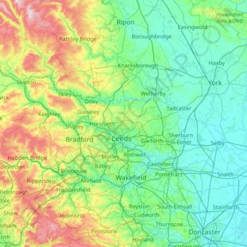
Nom : Carte topographique Airedale, altitude, relief.
Altitude moyenne : 58 m
Altitude minimum : 0 m
Altitude maximum : 372 m
Autres cartes topographiques
Cliquez sur une carte pour visualiser sa topographie, son altitude et son relief.
Little Driffield
United Kingdom > England > East Riding of Yorkshire > Driffield
Altitude moyenne : 30 m
Stamford Bridge
United Kingdom > England > East Riding of Yorkshire > Stamford Bridge
Altitude moyenne : 16 m