
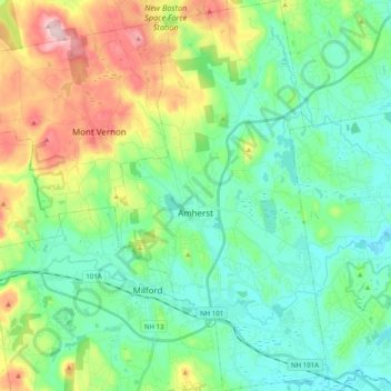
Carte topographique Amherst
Carte interactive
Cliquez sur la carte pour afficher l’altitude.
À propos de cette carte
Nom : Carte topographique Amherst, altitude, relief.
Altitude moyenne : 127 m
Altitude minimum : 50 m
Altitude maximum : 320 m
According to the United States Census Bureau, the town has a total area of 34.4 square miles (89.1 km2), of which 33.9 square miles (87.8 km2) are land and 0.50 square miles (1.3 km2), or 1.49% of the total area, are water. The entire town is part of the Merrimack River watershed. The Souhegan River, an east-flowing tributary of the Merrimack, passes through the southern part of the town, and the Souhegan's tributary Beaver Brook drains the central part of town and passes through the main village. Baboosic Lake is farther north, along the eastern border of the town and is fed by Joe English Brook. The lake drains to the east into Baboosic Brook, a tributary of the Merrimack. Pulpit Brook, which drains the northeast corner of the town, flows into Baboosic Brook as well. Witches Brook flows through the southernmost part of the town and is a tributary of Pennichuck Brook, yet another tributary of the Merrimack. Amherst's highest point is on Chestnut Hill at the town's northern border, where the elevation reaches 865 feet (264 m) above sea level.
Autres cartes topographiques
Cliquez sur une carte pour visualiser sa topographie, son altitude et son relief.
Nashua
United States > New Hampshire > Hillsborough County
Nashua, Hillsborough County, New Hampshire, United States
Altitude moyenne : 62 m
Manchester
United States > New Hampshire > Hillsborough County
Manchester, Hillsborough County, New Hampshire, United States
Altitude moyenne : 96 m
Bedford
United States > New Hampshire > Hillsborough County
Bedford, Hillsborough County, New Hampshire, 03110, United States
Altitude moyenne : 97 m
Lyndeborough
United States > New Hampshire > Hillsborough County
Lyndeborough, Hillsborough County, New Hampshire, 03082, United States
Altitude moyenne : 245 m
West Peterborough
United States > New Hampshire > Hillsborough County > Peterborough
West Peterborough, Peterborough, Hillsborough County, New Hampshire, 03468, United States
Altitude moyenne : 299 m
East Merrimack
United States > New Hampshire > Hillsborough County > Merrimack
East Merrimack, Merrimack, Hillsborough County, New Hampshire, 03054, United States
Altitude moyenne : 55 m
Pinardville
United States > New Hampshire > Hillsborough County > Goffstown
Pinardville, Goffstown, Hillsborough County, New Hampshire, 03102, United States
Altitude moyenne : 86 m
Grasmere
United States > New Hampshire > Hillsborough County > Goffstown
Grasmere, Goffstown, Hillsborough County, New Hampshire, 03045, United States
Altitude moyenne : 115 m
Reeds Ferry
United States > New Hampshire > Hillsborough County > Merrimack
Reeds Ferry, Merrimack, Hillsborough County, New Hampshire, 03054, United States
Altitude moyenne : 58 m
Horace Lake
United States > New Hampshire > Hillsborough County > Weare
Horace Lake, Weare, Hillsborough County, New Hampshire, United States
Altitude moyenne : 245 m
New Ipswich
United States > New Hampshire > Hillsborough County
New Ipswich, Hillsborough County, New Hampshire, 03071, United States
Altitude moyenne : 339 m
New Boston
United States > New Hampshire > Hillsborough County
New Boston, Hillsborough County, New Hampshire, 03070, United States
Altitude moyenne : 192 m
Pelham
United States > New Hampshire > Hillsborough County
Pelham, Hillsborough County, New Hampshire, 03076, United States
Altitude moyenne : 69 m
Goffstown
United States > New Hampshire > Hillsborough County
Goffstown, Hillsborough County, New Hampshire, 03045, United States
Altitude moyenne : 159 m
Weare
United States > New Hampshire > Hillsborough County
Weare, Hillsborough County, New Hampshire, United States
Altitude moyenne : 210 m
Peterborough
United States > New Hampshire > Hillsborough County
Peterborough, Hillsborough County, New Hampshire, United States
Altitude moyenne : 304 m
Sharon
United States > New Hampshire > Hillsborough County
Sharon, Hillsborough County, New Hampshire, United States
Altitude moyenne : 380 m
Brookline
United States > New Hampshire > Hillsborough County
Brookline, Hillsborough County, New Hampshire, 03033, United States
Altitude moyenne : 126 m
Merrimack River
United States > New Hampshire > Hillsborough County > Nashua
Merrimack River, Ward 3, Nashua, Hillsborough County, New Hampshire, United States
Altitude moyenne : 77 m
Antrim
United States > New Hampshire > Hillsborough County
Antrim, Hillsborough County, New Hampshire, 03440, United States
Altitude moyenne : 289 m
Shipley Hill
United States > New Hampshire > Hillsborough County > Nashua
Shipley Hill, Nashua, Hillsborough County, New Hampshire, 03039, United States
Altitude moyenne : 77 m
Joe English Hill
United States > New Hampshire > Hillsborough County > New Boston
Joe English Hill, New Boston, Hillsborough County, New Hampshire, 03070, United States
Altitude moyenne : 247 m
Hudson
United States > New Hampshire > Hillsborough County
Hudson, Hillsborough County, New Hampshire, 03051, United States
Altitude moyenne : 68 m
Hollis
United States > New Hampshire > Hillsborough County
Hollis, Hillsborough County, New Hampshire, United States
Altitude moyenne : 101 m
Gibson Four Corners
United States > New Hampshire > Hillsborough County > New Ipswich
Gibson Four Corners, New Ipswich, Hillsborough County, New Hampshire, 03071, United States
Altitude moyenne : 328 m
Riverdale
United States > New Hampshire > Hillsborough County > New Boston
Riverdale, New Boston, Hillsborough County, New Hampshire, United States
Altitude moyenne : 131 m
Litchfield
United States > New Hampshire > Hillsborough County
Litchfield, Hillsborough County, New Hampshire, 03052, United States
Altitude moyenne : 67 m
Greenville
United States > New Hampshire > Hillsborough County
Greenville, Hillsborough County, New Hampshire, United States
Altitude moyenne : 288 m
Hancock
United States > New Hampshire > Hillsborough County
Hancock, Hillsborough County, New Hampshire, 03449, United States
Altitude moyenne : 300 m
Nashua
United States > New Hampshire > Hillsborough County > Nashua
Nashua, Hillsborough County, New Hampshire, 03060-03064, United States
Altitude moyenne : 82 m
Mason
United States > New Hampshire > Hillsborough County
Mason, Hillsborough County, New Hampshire, 03048, United States
Altitude moyenne : 229 m
Mountain Base
United States > New Hampshire > Hillsborough County > Goffstown
Mountain Base, Goffstown, Hillsborough County, New Hampshire, 03045, United States
Altitude moyenne : 207 m
Cricket Corner
United States > New Hampshire > Hillsborough County > Amherst
Cricket Corner, Amherst, Hillsborough County, New Hampshire, 03031, United States
Altitude moyenne : 78 m
Massabesic Lake
United States > New Hampshire > Hillsborough County > Manchester
Massabesic Lake, Manchester, Hillsborough County, New Hampshire, United States
Altitude moyenne : 90 m
Deering
United States > New Hampshire > Hillsborough County
Deering, Hillsborough County, New Hampshire, United States
Altitude moyenne : 274 m
Temple
United States > New Hampshire > Hillsborough County
Temple, Hillsborough County, New Hampshire, 03084, United States
Altitude moyenne : 346 m
Mont Vernon
United States > New Hampshire > Hillsborough County
Mont Vernon, Hillsborough County, New Hampshire, 03057, United States
Altitude moyenne : 195 m
Hillsborough
United States > New Hampshire > Hillsborough County
Hillsborough, Hillsborough County, New Hampshire, 03244, United States
Altitude moyenne : 298 m
Manchester
United States > New Hampshire > Hillsborough County > Manchester
Manchester, Hillsborough County, New Hampshire, 03108, United States
Altitude moyenne : 126 m
Wilton
United States > New Hampshire > Hillsborough County
Wilton, Hillsborough County, New Hampshire, 03086, United States
Altitude moyenne : 178 m
Merrimack
United States > New Hampshire > Hillsborough County
Merrimack, Hillsborough County, New Hampshire, 03054, United States
Altitude moyenne : 68 m
Bennington
United States > New Hampshire > Hillsborough County
Bennington, Hillsborough County, New Hampshire, 03442, United States
Altitude moyenne : 260 m
Hillsborough
United States > New Hampshire > Hillsborough County
Hillsborough, Hillsborough County, New Hampshire, 03244, United States
Altitude moyenne : 253 m
Francestown
United States > New Hampshire > Hillsborough County
Francestown, Hillsborough County, New Hampshire, United States
Altitude moyenne : 276 m
Milford
United States > New Hampshire > Hillsborough County
Milford, Hillsborough County, New Hampshire, 03055, United States
Altitude moyenne : 114 m
Windsor
United States > New Hampshire > Hillsborough County
Windsor, Hillsborough County, New Hampshire, United States
Altitude moyenne : 375 m
Greenfield
United States > New Hampshire > Hillsborough County
Greenfield, Hillsborough County, New Hampshire, 03047, United States
Altitude moyenne : 288 m
MacDowell Colony
United States > New Hampshire > Hillsborough County > Peterborough
MacDowell Colony, Peterborough, Hillsborough County, New Hampshire, 03458, United States
Altitude moyenne : 261 m