
Carte topographique Orofino
Carte interactive
Cliquez sur la carte pour afficher l’altitude.
À propos de cette carte
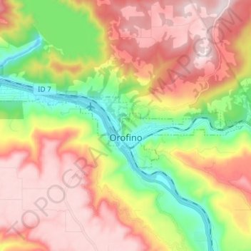
Nom : Carte topographique Orofino, altitude, relief.
Lieu : Orofino, Clearwater County, Idaho, 83544, United States (46.47097 -116.32122 46.49939 -116.19855)
Altitude moyenne : 633 m
Altitude minimum : 293 m
Altitude maximum : 964 m
Due to the area’s relatively low elevation, the climate is ranked as among the hottest in the summer and the mildest in the winter throughout the entire state. The moderate winters are also influenced by the city’s northwestern location, which places it closer to the Pacific Ocean than many other parts of Idaho. Idaho’s all-time highest temperature of 118 °F or 47.8 °C was recorded at Orofino on July 28, 1934.
Autres cartes topographiques
Cliquez sur une carte pour visualiser sa topographie, son altitude et son relief.
Weippe
United States > Idaho > Clearwater County
Weippe, Clearwater County, Idaho, 83553, United States
Altitude moyenne : 926 m
Ahsahka
United States > Idaho > Clearwater County
Ahsahka, Clearwater County, Idaho, 83520, United States
Altitude moyenne : 422 m
Elk River
United States > Idaho > Clearwater County
Elk River, Clearwater County, Idaho, 83827, United States
Altitude moyenne : 907 m
Pierce
United States > Idaho > Clearwater County
Pierce, Clearwater County, Idaho, 83546, United States
Altitude moyenne : 1’004 m
Orofino
United States > Idaho > Clearwater County > Orofino > Orofino
Orofino, Clearwater County, Idaho, 83544, United States
Altitude moyenne : 627 m