
Carte topographique Pittsburgh
Carte interactive
Cliquez sur la carte pour afficher l’altitude.
À propos de cette carte
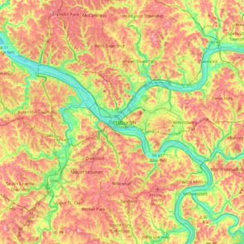
Nom : Carte topographique Pittsburgh, altitude, relief.
Altitude moyenne : 315 m
Altitude minimum : 209 m
Altitude maximum : 424 m
The warmest month of the year in Pittsburgh is July, with a 24-hour average of 72.6 °F (22.6 °C). Conditions are often humid, and combined with highs reaching 90 °F (32 °C) on an average 9.5 days a year, a considerable heat index arises. The coolest month is January, when the 24-hour average is 28.4 °F (−2.0 °C), and lows of 0 °F (−18 °C) or below can be expected on an average 2.6 nights per year. Officially, record temperatures range from −22 °F (−30 °C), on January 19, 1994 to 103 °F (39 °C), which occurred three times, most recently on July 16, 1988; the record cold daily maximum is −3 °F (−19 °C), which occurred three times, most recently the day of the all-time record low, while, conversely, the record warm daily minimum is 82 °F (28 °C) on July 1, 1901. Due to elevation and location on the windward side of the Appalachian Mountains, 100 °F (38 °C)+ readings are very rare, and were last seen on July 15, 1995.
Autres cartes topographiques
Cliquez sur une carte pour visualiser sa topographie, son altitude et son relief.
Middle Hill
United States of America > Pennsylvania > Pittsburgh
Middle Hill, Pittsburgh, Allegheny County, Pennsylvania, 15219, United States of America
Altitude moyenne : 283 m