
Carte topographique Winter Park
Carte interactive
Cliquez sur la carte pour afficher l’altitude.
À propos de cette carte
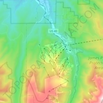
Nom : Carte topographique Winter Park, altitude, relief.
Lieu : Winter Park, Grand County, Colorado, United States (39.83223 -105.81202 39.93046 -105.74783)
Altitude moyenne : 3’068 m
Altitude minimum : 2’653 m
Altitude maximum : 3’994 m
Its elevation ranges from approximately 8,700 to 12,060 feet (2,650 to 3,680 m) above sea level, and is considered sub-alpine country. It is snow-covered for about six months a year. Although the town center is at about 9,000 feet (2,700 m) above sea level, Winter Park, using administrative boundaries as a measure, became the highest incorporated town in the United States after the July 2006 annexation of 5,214 acres (21.10 km2) of Winter Park Resort to allow new on-mountain improvements. This claim is disputed since Winter Park has no residences above 9,550 feet (2,910 m), while contiguous residential neighborhoods in Leadville, Colorado, extend to 10,360 feet (3,160 m) and in Alma, Colorado, to 11,680 feet (3,560 m), and Alma's town center is at 10,361 feet (3,158 m).
Autres cartes topographiques
Cliquez sur une carte pour visualiser sa topographie, son altitude et son relief.
Tabernash
United States > Colorado > Grand County > Tabernash
Tabernash, Grand County, Colorado, United States
Altitude moyenne : 2’593 m
Taylor Peak
United States > Colorado > Grand County
Taylor Peak, Grand County, Colorado, United States
Altitude moyenne : 3’646 m
Fraser
United States > Colorado > Grand County
Fraser, Grand County, Colorado, 80442, United States
Altitude moyenne : 2’696 m
Granby
United States > Colorado > Grand County
Granby, Grand County, Colorado, United States
Altitude moyenne : 2’555 m
Rock Creek
United States > Colorado > Grand County
Rock Creek, Grand County, Colorado, United States
Altitude moyenne : 2’724 m