
Carte topographique Lake City
Carte interactive
Cliquez sur la carte pour afficher l’altitude.
À propos de cette carte
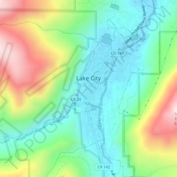
Nom : Carte topographique Lake City, altitude, relief.
Lieu : Lake City, Hinsdale County, Colorado, United States (38.01338 -107.32000 38.04394 -107.30126)
Altitude moyenne : 2’834 m
Altitude minimum : 2’630 m
Altitude maximum : 3’234 m
Lake City experiences a continental climate (Köppen climate classification Dfb) that only just escapes being classified as semi-arid due to its relatively wet early springs and late autumns. On average, the wettest month is August, and the driest is February. Very large daily temperature swings are a regular feature of Lake City's climate, due to the elevation and aridity.