
Carte topographique Île Bizard
Carte interactive
Cliquez sur la carte pour afficher l’altitude.
À propos de cette carte
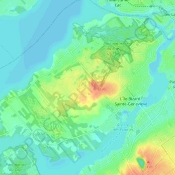
Nom : Carte topographique Île Bizard, altitude, relief.
Altitude moyenne : 29 m
Altitude minimum : 18 m
Altitude maximum : 58 m
Autres cartes topographiques
Cliquez sur une carte pour visualiser sa topographie, son altitude et son relief.
Mount Royal
Canada > Quebec > Urban agglomeration of Montreal > Montreal
Mount Royal, Montreal, Urban agglomeration of Montreal, Montreal (administrative region), Quebec, H3A 2B7, Canada
Altitude moyenne : 111 m
Rivière des Prairies
Canada > Quebec > Urban agglomeration of Montreal > Montreal
Rivière des Prairies, Montreal, Urban agglomeration of Montreal, Montreal (administrative region), Quebec, Canada
Altitude moyenne : 36 m
Parc de la Rive-Boisée
Canada > Quebec > Urban agglomeration of Montreal > Montreal
Parc de la Rive-Boisée, Pierrefonds-Roxboro, Montreal, Urban agglomeration of Montreal, Montreal (administrative region), Quebec, Canada
Altitude moyenne : 29 m
Rivière des Prairies
Canada > Quebec > Urban agglomeration of Montreal > Montreal
Rivière des Prairies, Montreal, Urban agglomeration of Montreal, Montreal (administrative region), Quebec, Canada
Altitude moyenne : 34 m
Pierrefonds-Roxboro
Canada > Quebec > Urban agglomeration of Montreal > Montreal
Pierrefonds-Roxboro, Montreal, Urban agglomeration of Montreal, Montreal (06), Quebec, Canada
Altitude moyenne : 30 m
Mount Royal Park
Canada > Quebec > Urban agglomeration of Montreal > Montreal
Mount Royal Park, Ville-Marie, Montreal, Urban agglomeration of Montreal, Montreal (administrative region), Quebec, H3G 1A8, Canada
Altitude moyenne : 110 m
LaSalle
Canada > Quebec > Urban agglomeration of Montreal > Montreal
LaSalle, Montreal, Urban agglomeration of Montreal, Montreal (administrative region), Quebec, Canada
Altitude moyenne : 30 m
Parc Richelieu
Canada > Quebec > Urban agglomeration of Montreal > Montreal
Parc Richelieu, Pointe-aux-Trembles, Rivière-des-Prairies–Pointe-aux-Trembles, Montreal, Urban agglomeration of Montreal, Montreal (administrative region), Quebec, Canada
Altitude moyenne : 15 m
Lachine
Canada > Quebec > Urban agglomeration of Montreal > Montreal
Lachine, Montreal, Urban agglomeration of Montreal, Montreal (administrative region), Quebec, Canada
Altitude moyenne : 34 m
Nuns' Island
Canada > Quebec > Urban agglomeration of Montreal > Montreal
Nuns' Island, Verdun, Montreal, Urban agglomeration of Montreal, Montreal (06), Quebec, Canada
Altitude moyenne : 13 m
Montréal-Nord
Canada > Quebec > Urban agglomeration of Montreal > Montreal
Montréal-Nord, Montreal, Urban agglomeration of Montreal, Montreal (administrative region), Quebec, Canada
Altitude moyenne : 31 m
Outremont
Canada > Quebec > Urban agglomeration of Montreal > Montreal
Outremont, Montreal, Urban agglomeration of Montreal, Montreal (06), Quebec, Canada
Altitude moyenne : 106 m
Parc-nature du Bois-de-Liesse
Canada > Quebec > Urban agglomeration of Montreal > Montreal
Parc-nature du Bois-de-Liesse, Boucle des Champs-Pitfield, Bois-Francs, Saint-Laurent, Montreal, Urban agglomeration of Montreal, Montreal (06), Quebec, H4S 0A3, Canada
Altitude moyenne : 28 m
Verdun
Canada > Quebec > Urban agglomeration of Montreal > Montreal
Verdun, Montreal, Urban agglomeration of Montreal, Montreal (administrative region), Quebec, Canada
Altitude moyenne : 18 m