
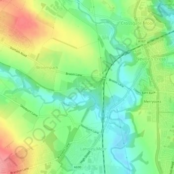
Carte topographique Broompark Picnic Area
Carte interactive
Cliquez sur la carte pour afficher l’altitude.
À propos de cette carte
Nom : Carte topographique Broompark Picnic Area, altitude, relief.
Altitude moyenne : 94 m
Altitude minimum : 56 m
Altitude maximum : 150 m
Autres cartes topographiques
Cliquez sur une carte pour visualiser sa topographie, son altitude et son relief.
Durham Castle
United Kingdom > England > Durham
Durham Castle, Moatside Lane, City of Durham, Durham, County Durham, North East England, England, DH1 3RB, United Kingdom
Altitude moyenne : 70 m
River Balder
United Kingdom > England > Durham
River Balder, Durham, County Durham, North East England, England, DL12 9QS, United Kingdom
Altitude moyenne : 238 m
River Gaunless
United Kingdom > England > Durham
River Gaunless, Durham, County Durham, North East England, England, DL13 5HU, United Kingdom
Altitude moyenne : 193 m