
Carte topographique Lincolnshire Wolds National Landscape
Carte interactive
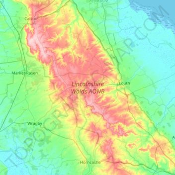
Cliquez sur la carte pour afficher l’altitude.
À propos de cette carte
Nom : Carte topographique Lincolnshire Wolds National Landscape, altitude, relief.
Altitude moyenne : 48 m
Altitude minimum : -1 m
Altitude maximum : 170 m
Autres cartes topographiques
Cliquez sur une carte pour visualiser sa topographie, son altitude et son relief.
Three Kings Deer
United Kingdom > England > Lincolnshire > North Kesteven > Threekingham
Altitude moyenne : 24 m
Belleau Bridge
United Kingdom > England > Lincolnshire > East Lindsey > Aby > Belleau
Altitude moyenne : 30 m
Holbeach Clough
United Kingdom > England > Lincolnshire > South Holland > Holbeach CP > Saracen's Head
Altitude moyenne : 4 m
Scottlethorpe
United Kingdom > England > Lincolnshire > South Kesteven > Edenham
Altitude moyenne : 49 m
Louth Navigation
United Kingdom > England > Lincolnshire > East Lindsey > Alvingham
Altitude moyenne : 8 m
Caen Hill
United Kingdom > England > Lincolnshire > West Lindsey > Great Limber CP
Altitude moyenne : 83 m
Halton Fenside
United Kingdom > England > Lincolnshire > East Lindsey > Little Steeping
Altitude moyenne : 8 m
Bishopbridge
United Kingdom > England > Lincolnshire > West Lindsey > Osgodby CP
Altitude moyenne : 10 m
Rase Park
United Kingdom > England > Lincolnshire > West Lindsey > Market Rasen
Altitude moyenne : 28 m
Spalding Marsh
United Kingdom > England > Lincolnshire > South Holland > Weston CP
Altitude moyenne : 4 m
Quarrington
United Kingdom > England > Lincolnshire > North Kesteven
According to the Köppen classification, the British Isles experience a maritime climate characterised by relatively cool summers and mild winters. Lincolnshire's position on the east of the Isles allows for a sunnier and warmer climate relative to the national average, and it is one of the driest counties in…
Altitude moyenne : 21 m
Wainfleet Haven
United Kingdom > England > Lincolnshire > East Lindsey > Wainfleet Clough
Altitude moyenne : 3 m
Sempringham
United Kingdom > England > Lincolnshire > South Kesteven > Pointon
Sempringham consists of a church and a holy well, with other houses east from the church scattered along the B1177 between Pointon and Billingborough. The church stands at an altitude of about 52 feet (16 m), on land rising out of flat fenland. Pointon is the chief township of the civil parish, which includes…
Altitude moyenne : 16 m
Low Fulney Estate
United Kingdom > England > Lincolnshire > South Holland > Spalding
Altitude moyenne : 4 m