
Carte topographique Appalachian Mountains
Carte interactive
Cliquez sur la carte pour afficher l’altitude.
À propos de cette carte
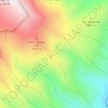
Nom : Carte topographique Appalachian Mountains, altitude, relief.
Altitude moyenne : 1’463 m
Altitude minimum : 962 m
Altitude maximum : 2’002 m
The Appalachian Mountains (French: Appalaches), often called the Appalachians, are a system of mountains in eastern to northeastern North America. The Appalachians first formed roughly 480 million years ago during the Ordovician Period. They once reached elevations similar to those of the Alps and the Rocky Mountains before experiencing natural erosion. The Appalachian chain is a barrier to east–west travel, as it forms a series of alternating ridgelines and valleys oriented in opposition to most highways and railroads running east–west.
Autres cartes topographiques
Cliquez sur une carte pour visualiser sa topographie, son altitude et son relief.
Burnsville
United States > North Carolina > Yancey County
Burnsville, Yancey County, North Carolina, United States
Altitude moyenne : 882 m
Mount Mitchell
United States > North Carolina > Yancey County
Mount Mitchell, Yancey County, North Carolina, United States
Altitude moyenne : 1’743 m
Mitchell Ridge
United States > North Carolina > Yancey County
Mitchell Ridge, Yancey County, North Carolina, United States
Altitude moyenne : 1’517 m
Cane River
United States > North Carolina > Yancey County > Low Gap
Cane River, Low Gap, Yancey County, North Carolina, 28714, United States
Altitude moyenne : 944 m
Cane River
United States > North Carolina > Yancey County > Eskota
Cane River, Eskota, Yancey County, North Carolina, United States
Altitude moyenne : 1’154 m
Lost Cove
United States > North Carolina > Yancey County > Lost Cove
Lost Cove, Yancey County, North Carolina, United States
Altitude moyenne : 852 m