
Carte topographique Bucks County
Carte interactive
Cliquez sur la carte pour afficher l’altitude.
Bucks County
According to the Trewartha climate classification system, the Piedmont (United States) section of Bucks County, which is located roughly northwest of U.S. Route 1, has a Temperate Continental Climate with hot and slightly humid summers, cold winters and year-around precipitation (Dcao). Dcao climates are characterized by at least one month having an average mean temperature ≤ 32.0 °F (0 °C), four to seven months with an average mean temperature ≥ 50.0 °F (10 °C), at least one month with an average mean temperature ≥ 72.0 °F (22 °C) and no significant precipitation difference between seasons. According to the Köppen climate classification system, the climate is a hot-summer, wet all year, humid continental climate (Dfa). During the summer months in the Piedmont, episodes of extreme heat and humidity can occur with heat index values > 102 °F (39 °C). The average wettest month is July which corresponds with the annual peak in thunderstorm activity. During the winter months, episodes of extreme cold and wind can occur with wind chill values < −16 °F (−27 °C). The plant hardiness zone at Haycock Mountain, elevation 968 ft (295 m), is 6b with an average annual extreme minimum air temperature of −4.6 °F (−20 °C). The average seasonal (Nov-Apr) snowfall total is between 26 and 36 inches (66 and 91 cm) depending on elevation and distance from the Atlantic Ocean. The average snowiest month is February which correlates with the annual peak in nor'easter activity. Some areas of the Piedmont farther south and along the river below New Hope are in hardiness zone 7a, as is the Atlantic Coastal Plain region of Bucks.
À propos de cette carte
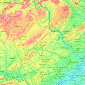
Nom : Carte topographique Bucks County, altitude, relief.
Lieu : Bucks County, Pennsylvania, United States (40.04980 -75.48393 40.60872 -74.72111)
Altitude moyenne : 98 m
Altitude minimum : -2 m
Altitude maximum : 312 m
Autres cartes topographiques
Cliquez sur une carte pour visualiser sa topographie, son altitude et son relief.
Lake Ontelaunee Dam
United States > Pennsylvania > Berks County > Ontelaunee Township
Altitude moyenne : 99 m
Chickies Rock
United States > Pennsylvania > Lancaster County > West Hempfield Township
Altitude moyenne : 106 m
Buck Hill Falls
United States > Pennsylvania > Monroe County > Barrett Township > Mountainhome
Altitude moyenne : 380 m
Lewis Rocks
United States > Pennsylvania > Cumberland County > Southampton Township
Altitude moyenne : 462 m
Danielsville
United States > Pennsylvania > Northampton County > Lehigh Township
Altitude moyenne : 254 m
Sunset Rocks
United States > Pennsylvania > Cumberland County > Cooke Township
Altitude moyenne : 357 m
Vestaburg
United States > Pennsylvania > Washington County > East Bethlehem Township
Altitude moyenne : 308 m
Blainsport
United States > Pennsylvania > Lancaster County > West Cocalico Township
Altitude moyenne : 174 m
Hemlock Farms
United States > Pennsylvania > Pike County > Blooming Grove Township
Altitude moyenne : 437 m
Great Wolf Lodge Water Park
United States > Pennsylvania > Monroe County > Pocono Township > Scotrun
Altitude moyenne : 354 m
Huntingdon Valley
United States > Pennsylvania > Montgomery County > Lower Moreland Township
Altitude moyenne : 65 m
Moween
United States > Pennsylvania > Westmoreland County > Loyalhanna Township
Altitude moyenne : 319 m
Pipersville
United States > Pennsylvania > Bucks County > Bedminster Township
Altitude moyenne : 125 m
Blue Mountain
United States > Pennsylvania > Schuylkill County > West Penn Township
The ridge of Blue Mountain runs for 150 miles (240 km) through Pennsylvania, reaching an elevation of 2,270 feet (690 m) above sea level just north of the Pennsylvania Turnpike, near the borough of Newburg. Most of the ridgecrest, however, only reaches between 1,400 and 1,700 feet (430 and 520 m) in elevation.…
Altitude moyenne : 251 m
Washington Crossing
United States > Pennsylvania > Bucks County > Upper Makefield Township
Altitude moyenne : 36 m
Moosic Lakes
United States > Pennsylvania > Lackawanna County > Jefferson Township
Altitude moyenne : 617 m
Mount Cobb
United States > Pennsylvania > Lackawanna County > Jefferson Township
Altitude moyenne : 529 m
Eagle Rock
United States > Pennsylvania > Lancaster County > Elizabeth Township
Altitude moyenne : 193 m
Upper Black Eddy
United States > Pennsylvania > Bucks County > Bridgeton Township
Altitude moyenne : 100 m
Town Hill
United States > Pennsylvania > Luzerne County > Huntington Township
Altitude moyenne : 281 m
Crestwood
United States > Pennsylvania > Lackawanna County > Roaring Brook Township
Altitude moyenne : 512 m
Pennsville
United States > Pennsylvania > Northampton County > Lehigh Township
Altitude moyenne : 191 m
Lake Wesauking
United States > Pennsylvania > Bradford County > Wysox Township
Altitude moyenne : 355 m
Whitehorse
United States > Pennsylvania > Chester County > Willistown Township
Altitude moyenne : 117 m
Alverton
United States > Pennsylvania > Westmoreland County > East Huntingdon Township
Altitude moyenne : 361 m
Windham Summit
United States > Pennsylvania > Bradford County > Windham Township
Altitude moyenne : 430 m
Alice
United States > Pennsylvania > Westmoreland County > Mount Pleasant Township
Altitude moyenne : 450 m
Solomon Gap
United States > Pennsylvania > Luzerne County > Fairview Township > Fairview
Altitude moyenne : 479 m
Mount Hope
United States > Pennsylvania > Adams County > Hamiltonban Township
Altitude moyenne : 395 m
Hazel Kirk
United States > Pennsylvania > Washington County > Carroll Township
Altitude moyenne : 311 m
Port Bowkley
United States > Pennsylvania > Luzerne County > Plains Township > Plains
Altitude moyenne : 177 m
Nittany Valley
United States > Pennsylvania > Clinton County > Porter Township
Nittany Valley is in the western part of the Ridge and Valley province of the Appalachian Mountains. During the Appalachian orogeny, the sedimentary rock layers folded up into the Nittany Arch anticline. The arch was an ancient Himalayan scale mountain that towered above what is now the valley. The oldest rock…
Altitude moyenne : 362 m
Indian Rocks
United States > Pennsylvania > Lancaster County > East Cocalico Township
Altitude moyenne : 161 m
Madisonville
United States > Pennsylvania > Lackawanna County > Madison Township
Altitude moyenne : 512 m
Lake Harmony
United States > Pennsylvania > Carbon County > Kidder Township > Lake Harmony
Altitude moyenne : 568 m
Georgetown
United States > Pennsylvania > Luzerne County > Wilkes-Barre Township
Altitude moyenne : 267 m
Sand Springs
United States > Pennsylvania > Mifflin County > Bratton Township
Altitude moyenne : 449 m
Pilgrim Gardens
United States > Pennsylvania > Delaware County > Haverford Township
Altitude moyenne : 76 m
Fredericktown
United States > Pennsylvania > Washington County > East Bethlehem Township
Altitude moyenne : 306 m
Eagleville
United States > Pennsylvania > Montgomery County > Lower Providence Township
Altitude moyenne : 102 m
Millsboro
United States > Pennsylvania > Washington County > East Bethlehem Township
Altitude moyenne : 308 m
Rosegarden
United States > Pennsylvania > Cumberland County > Upper Allen Township
Altitude moyenne : 143 m
Glen Moore
United States > Pennsylvania > Lancaster County > Manheim Township
Altitude moyenne : 109 m
Enterprise
United States > Pennsylvania > Washington County > South Strabane Township
Altitude moyenne : 334 m
Heart Lake
United States > Pennsylvania > Susquehanna County > Bridgewater Township
Altitude moyenne : 482 m
Shirks Corner
United States > Pennsylvania > Montgomery County > Upper Salford Township
Altitude moyenne : 80 m
East New Castle
United States > Pennsylvania > Lawrence County > Shenango Township
Altitude moyenne : 318 m
Walbert
United States > Pennsylvania > Lehigh County > South Whitehall Township
Altitude moyenne : 137 m
Grove Hill
United States > Pennsylvania > Clinton County > West Keating Township
Altitude moyenne : 464 m
Christian Corner
United States > Pennsylvania > Carbon County > Lower Towamensing Township
Altitude moyenne : 226 m
Patience
United States > Pennsylvania > Bedford County > Cumberland Valley Township
Altitude moyenne : 464 m
Hickory
United States > Pennsylvania > Washington County > Mount Pleasant Township
Altitude moyenne : 371 m
Susquehanna State Park
United States > Pennsylvania > Lycoming County > Williamsport
Altitude moyenne : 206 m
Perkiomen Place
United States > Pennsylvania > Montgomery County > East Greenville
Altitude moyenne : 112 m