
Carte topographique Claypotts Castle
Carte interactive
Cliquez sur la carte pour afficher l’altitude.
À propos de cette carte
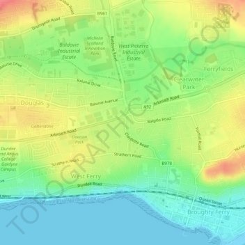
Nom : Carte topographique Claypotts Castle, altitude, relief.
Altitude moyenne : 28 m
Altitude minimum : 0 m
Altitude maximum : 66 m
Autres cartes topographiques
Cliquez sur une carte pour visualiser sa topographie, son altitude et son relief.
Broughty Castle
United Kingdom > Scotland > Dundee City > Dundee
Broughty Castle, Castle Approach, Broughty Ferry, Dundee, Dundee City, Scotland, DD5 2TF, United Kingdom
Altitude moyenne : 10 m
Camperdown Country Park
United Kingdom > Scotland > Dundee City > Dundee
Camperdown Country Park, Dundee, Dundee City, Scotland, DD2 4TF, United Kingdom
Altitude moyenne : 120 m
Drumgeith Park
United Kingdom > Scotland > Dundee City > Dundee
Drumgeith Park, Whitfield, Dundee, Dundee City, Scotland, United Kingdom
Altitude moyenne : 54 m