
Carte topographique Dawson County
Carte interactive
Cliquez sur la carte pour afficher l’altitude.
À propos de cette carte
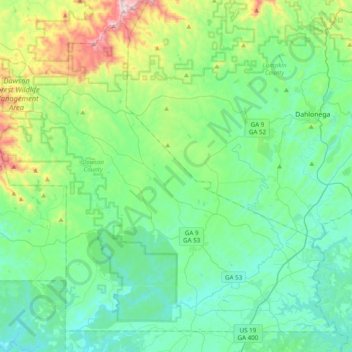
Nom : Carte topographique Dawson County, altitude, relief.
Lieu : Dawson County, Georgia, 30534, United States (34.33401 -84.34649 34.61763 -83.95708)
Altitude moyenne : 462 m
Altitude minimum : 281 m
Altitude maximum : 1’140 m
The county is located in the foothills of the Blue Ridge Mountains. Portions of the mountain chain extend into the far northern and western portions of the county, with elevations around 3,500 ft. in this area.
Autres cartes topographiques
Cliquez sur une carte pour visualiser sa topographie, son altitude et son relief.
Atlanta
United States > Georgia > Fulton County
Atlanta, Fulton County, Georgia, United States
Altitude moyenne : 284 m
Savannah
United States > Georgia > Chatham County
Savannah, Chatham County, Georgia, United States
Altitude moyenne : 4 m
Dahlonega
United States > Georgia > Lumpkin County
Dahlonega, Lumpkin County, Georgia, United States
Altitude moyenne : 411 m
Augusta
United States > Georgia > Augusta
Augusta, Richmond County, Georgia, 30901, United States
Altitude moyenne : 90 m
Athens
United States > Georgia > Athens
Athens, Athens-Clarke County, Georgia, 303341458, United States
Altitude moyenne : 221 m
Georgia International Horse Park
United States > Georgia > Rockdale County > Conyers
Georgia International Horse Park, Conyers, Rockdale County, Georgia, United States
Altitude moyenne : 209 m
Helen
United States > Georgia > White County
Helen, White County, Georgia, 30545, United States
Altitude moyenne : 488 m
Blue Ridge
United States > Georgia > Fannin County
Blue Ridge, Fannin County, Georgia, United States
Altitude moyenne : 535 m
Gwinnett County
Gwinnett County, Georgia, United States
Altitude moyenne : 302 m
Ellijay
United States > Georgia > Gilmer County
Ellijay, Gilmer County, Georgia, 30540, United States
Altitude moyenne : 424 m
Tybee Island
United States > Georgia > Chatham County
Tybee Island, Chatham County, Georgia, 31328, United States
Altitude moyenne : 1 m
Saint Simons Island
United States > Georgia > Glynn County
Saint Simons Island, Glynn County, Georgia, 31561, United States
Altitude moyenne : 2 m
Macon
United States > Georgia > Bibb County
Macon, Bibb County, Georgia, United States
Altitude moyenne : 127 m
Atlanta
United States > Georgia > Fulton County
Atlanta, Fulton County, Georgia, 30303, United States
Altitude moyenne : 285 m
Alpharetta
United States > Georgia > Fulton County
Alpharetta, Fulton County, Georgia, United States
Altitude moyenne : 324 m
Blairsville
United States > Georgia > Union County
Blairsville, Union County, Georgia, United States
Altitude moyenne : 587 m
Columbus
United States > Georgia > Muscogee County
Columbus, Muscogee County, Georgia, United States
Altitude moyenne : 130 m
Vinings
United States > Georgia > Cobb County
Vinings, Cobb County, Georgia, 30339, United States
Altitude moyenne : 281 m
Hiawassee
United States > Georgia > Towns County
Hiawassee, Towns County, Georgia, United States
Altitude moyenne : 620 m
Skidaway Island
United States > Georgia > Chatham County
Skidaway Island, Chatham County, Georgia, 31411, United States
Altitude moyenne : 3 m
Brunswick
United States > Georgia > Glynn County
Brunswick, Glynn County, Georgia, United States
Altitude moyenne : 2 m
Lumpkin
United States > Georgia > Stewart County
Lumpkin, Stewart County, Georgia, United States
Altitude moyenne : 147 m
Gainesville
United States > Georgia > Hall County
Gainesville, Hall County, Georgia, 30501, United States
Altitude moyenne : 346 m
Canton
United States > Georgia > Cherokee County
Canton, Cherokee County, Georgia, United States
Altitude moyenne : 320 m
Jointer Island
United States > Georgia > Glynn County > Brunswick
Jointer Island, Brunswick, Glynn County, Georgia, United States
Altitude moyenne : 0 m
Heritage Acres
United States > Georgia > Bibb County > Macon
Heritage Acres, Macon, Bibb County, Georgia, 31211, United States
Altitude moyenne : 119 m
Robins Air Force Base
United States > Georgia > Houston County
Robins Air Force Base, Houston County, Georgia, 31098, United States
Altitude moyenne : 92 m
Stone Mountain
United States > Georgia > DeKalb County
Stone Mountain, DeKalb County, Georgia, 30087, United States
Altitude moyenne : 299 m
Woodstock
United States > Georgia > Cherokee County
Woodstock, Cherokee County, Georgia, United States
Altitude moyenne : 296 m
Mountain City
United States > Georgia > Rabun County
Mountain City, Rabun County, Georgia, 30562, United States
Altitude moyenne : 747 m
Lake Oconee
United States > Georgia > Greene County > Lake Oconee
Lake Oconee, Greene County, Georgia, United States
Altitude moyenne : 165 m
Kennesaw
United States > Georgia > Cobb County
Kennesaw, Cobb County, Georgia, 30144, United States
Altitude moyenne : 317 m
Iron Mountain
United States > Georgia > Murray County
Iron Mountain, Murray County, Georgia, United States
Altitude moyenne : 362 m
Fort Pulaski
United States > Georgia > Chatham County
Fort Pulaski, Fort Perimeter Trail, Chatham County, Georgia, 31328, United States
Altitude moyenne : 1 m
Tugaloo
United States > Georgia > Habersham County > Tallulah Falls
Tugaloo, Tallulah Falls, Habersham County, Georgia, United States
Altitude moyenne : 392 m
Elmodel
United States > Georgia > Baker County
Elmodel, Baker County, Georgia, United States
Altitude moyenne : 51 m
Leary
United States > Georgia > Calhoun County
Leary, Calhoun County, Georgia, 39862, United States
Altitude moyenne : 61 m
Fargo
United States > Georgia > Clinch County
Fargo, Clinch County, Georgia, United States
Altitude moyenne : 34 m
Worley Crossroads
United States > Georgia > Cherokee County
Worley Crossroads, Cherokee County, Georgia, United States
Altitude moyenne : 378 m
Fernwood
United States > Georgia > Fayette County > Peachtree City
Fernwood, Peachtree City, Fayette County, Georgia, 30269, United States
Altitude moyenne : 261 m