Géolocaliser

Carte topographique Fatehabad

Carte interactive

Cliquez sur la carte pour afficher l’altitude.

À propos de cette carte

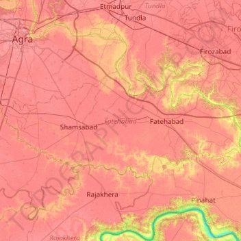
Nom : Carte topographique Fatehabad, altitude, relief.

Lieu : Fatehabad, Agra, Uttar Pradesh, 283111, Inde (26.92574 77.96765 27.12942 78.45333)

Altitude moyenne : 160 m

Altitude minimum : 106 m

Altitude maximum : 181 m

Autres cartes topographiques

Cliquez sur une carte pour visualiser sa topographie, son altitude et son relief.

Lucknow

Inde > Uttar Pradesh > Lucknow

Lucknow, Uttar Pradesh, 226027, Inde

Altitude moyenne : 120 m

Beel Akbarpur

Inde > Uttar Pradesh > Beel Akbarpur

Beel Akbarpur, Ghaziabad, Uttar Pradesh, 201314, Inde

Altitude moyenne : 208 m

Chandan Chowky

Inde > Uttar Pradesh > Chandan Chowky

Chandan Chowky, Kheri, Uttar Pradesh, Inde

Altitude moyenne : 159 m

Yamuna

Inde > Uttar Pradesh

Yamuna, Firozabad, Uttar Pradesh, 282004, Inde

Altitude moyenne : 707 m

Gange

Inde > Uttar Pradesh

Gange, Ghāzīpur, Ghazipur, Uttar Pradesh, 249304, Inde

Altitude moyenne : 1’626 m