Carte topographique Almora
Carte interactive
Cliquez sur la carte pour afficher l’altitude.
À propos de cette carte
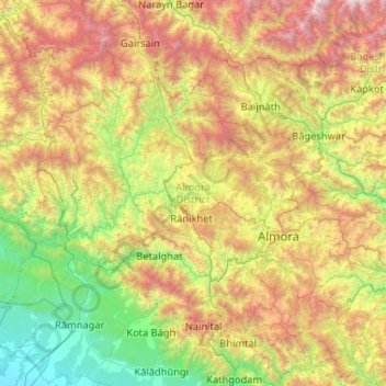
Nom : Carte topographique Almora, altitude, relief.
Lieu : Almora, Uttarakhand, Inde (29.42718 79.02514 29.97906 80.07832)
Altitude moyenne : 1’443 m
Altitude minimum : 235 m
Altitude maximum : 4’134 m
Autres cartes topographiques
Cliquez sur une carte pour visualiser sa topographie, son altitude et son relief.
Nanda Devi
Inde > Uttarakhand > Joshimath Tehsil
Nanda Devi, Joshimath Tehsil, Chamoli District, Uttarakhand, Inde
Altitude moyenne : 6’567 m
Chamoli
Inde > Uttarakhand > Chamoli Tehsil
Chamoli, Chamoli Tehsil, Chamoli district, Uttarakhand, 246426, Inde
Altitude moyenne : 1’425 m
Chari
Inde > Uttarakhand > Dwarahat
Chari, Dwarahat, Almora, Uttarakhand, Inde
Altitude moyenne : 1’985 m
Aquarium
Inde > Uttarakhand > Bhimtal
Aquarium, Bhimtal, Nainital, Uttarakhand, 263136, Inde
Altitude moyenne : 1’426 m
Bhagirathi River
Bhagirathi River, Uttarkashi, Uttarakhand, 249151, Inde
Altitude moyenne : 2’258 m
Tehri-Garhwal
Tehri-Garhwal, Tehri Garhwal, Uttarakhand, Inde
Altitude moyenne : 2’339 m