
Carte topographique Edenderry
Carte interactive
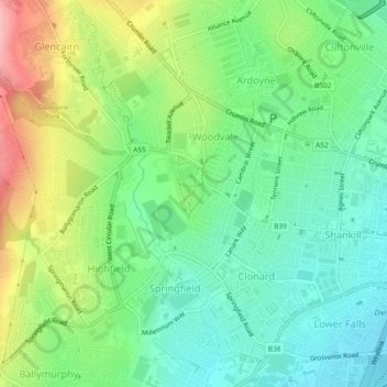
Cliquez sur la carte pour afficher l’altitude.
À propos de cette carte
Nom : Carte topographique Edenderry, altitude, relief.
Altitude moyenne : 50 m
Altitude minimum : 2 m
Altitude maximum : 138 m
Autres cartes topographiques
Cliquez sur une carte pour visualiser sa topographie, son altitude et son relief.
Ballygomartin
United Kingdom > Northern Ireland > County Antrim > Belfast
Ballygomartin, Ligoniel, Belfast, County Antrim, Northern Ireland, United Kingdom
Altitude moyenne : 258 m
Botanic Gardens
United Kingdom > Northern Ireland > County Antrim > Belfast
Botanic Gardens, Queen's Quarter, Belfast, County Antrim, Northern Ireland, United Kingdom
Altitude moyenne : 15 m
Cavehill
United Kingdom > Northern Ireland > County Antrim > Belfast
Cavehill, Belfast, County Antrim, Northern Ireland, BT36 7PN, United Kingdom
Altitude moyenne : 188 m
McArt's Fort
United Kingdom > Northern Ireland > County Antrim > Belfast
McArt's Fort, Ben Madigan Heights, Whitewell, Belfast, County Antrim, Northern Ireland, BT36 7RW, United Kingdom
Altitude moyenne : 165 m