
Carte topographique Texas City
Carte interactive
Cliquez sur la carte pour afficher l’altitude.
À propos de cette carte
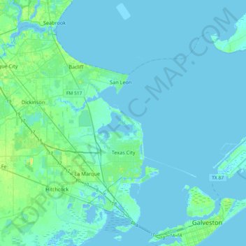
Nom : Carte topographique Texas City, altitude, relief.
Lieu : Texas City, Galveston County, Texas, United States (29.30097 -95.07828 29.56638 -94.71429)
Altitude moyenne : 2 m
Altitude minimum : -8 m
Altitude maximum : 19 m
Officially, the elevation of Texas City is 10 feet above sea level, though some areas are even lower. It was naturally vulnerable to flooding by hurricane storm surges and heavy rainstorms.
Autres cartes topographiques
Cliquez sur une carte pour visualiser sa topographie, son altitude et son relief.
Max's Creek
United States > Texas > Galveston County > Friendswood
Max's Creek, West Ranch, Friendswood, Galveston County, Texas, United States
Altitude moyenne : 10 m
Dickinson
United States > Texas > Galveston County
Dickinson, Galveston County, Texas, 77539, United States
Altitude moyenne : 6 m
League City
United States > Texas > Galveston County > League City > League City
League City, Galveston County, Texas, 77573, United States
Altitude moyenne : 7 m
League City
United States > Texas > Galveston County
League City, Galveston County, Texas, 77573, United States
Altitude moyenne : 7 m
Kemah
United States > Texas > Galveston County > Kemah
Kemah, Galveston County, Texas, United States
Altitude moyenne : 5 m
Galveston
United States > Texas > Galveston County > Galveston
Galveston, Galveston County, Texas, 77553, United States
Altitude moyenne : 1 m
Galveston
United States > Texas > Galveston County
Galveston, Galveston County, Texas, United States
Altitude moyenne : 1 m
Friendswood
United States > Texas > Galveston County
Friendswood, Galveston County, Texas, 77546, United States
Altitude moyenne : 11 m