Carte topographique Arni
Carte interactive
Cliquez sur la carte pour afficher l’altitude.
À propos de cette carte
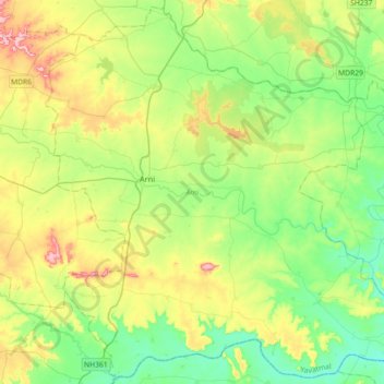
Nom : Carte topographique Arni, altitude, relief.
Lieu : Arni, Yavatmal, Maharashtra, 445103, Inde (19.89038 77.85745 20.21642 78.21747)
Altitude moyenne : 305 m
Altitude minimum : 236 m
Altitude maximum : 447 m
Autres cartes topographiques
Cliquez sur une carte pour visualiser sa topographie, son altitude et son relief.
Parle
Inde > Maharashtra > Chandgad
Parle, Chandgad, Kolhapur, Maharashtra, Inde
Altitude moyenne : 716 m
Fagne
Inde > Maharashtra > Dhule
Fagne, Dhule, Dhule District, Maharashtra, 424301, Inde
Altitude moyenne : 261 m
Lat
Inde > Maharashtra > Lat
Lat, Shirol, Kolhapur district, Maharashtra, Inde
Altitude moyenne : 542 m
Walunj
Inde > Maharashtra > Walunj
Walunj, Nagar, Ahmednagar, Maharashtra, 414006, Inde
Altitude moyenne : 632 m
Kolhapur
Inde > Maharashtra > Kolhapur
Kolhapur, Kolhapur district, Maharashtra, 416003, Inde
Altitude moyenne : 592 m
Jaysingpur
Inde > Maharashtra > Jaysingpur
Jaysingpur, Shirol, Kolhapur, Maharashtra, 416101, Inde
Altitude moyenne : 554 m
सांगली
Inde > Maharashtra > सांगली
सांगली, Sangli, Sangli district, Maharashtra, Inde
Altitude moyenne : 559 m
Borale
Inde > Maharashtra > Borale
Borale, Nandubar, Maharashtra, 425422, Inde
Altitude moyenne : 118 m
Tarapur
Inde > Maharashtra > Tarapur
Tarapur, Palghar, Maharashtra, 401502, Inde
Altitude moyenne : 5 m