
Carte topographique Winter Garden
Carte interactive
Cliquez sur la carte pour afficher l’altitude.
À propos de cette carte
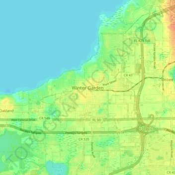
Nom : Carte topographique Winter Garden, altitude, relief.
Altitude moyenne : 31 m
Altitude minimum : 16 m
Altitude maximum : 54 m
The terrain is characterized by a gentle to moderately sloping topography. Winter Garden has the highest elevation spot in Orange County. The highest elevation is 222 feet (68 m) in NAVD 88 (North American Vertical Datum) located in the southwest corner of the city South near the county line with Lake County. The lowest elevation in the city is 64 feet (20 m) near Lake Apopka.