Carte topographique Augusta
Carte interactive
Cliquez sur la carte pour afficher l’altitude.
À propos de cette carte
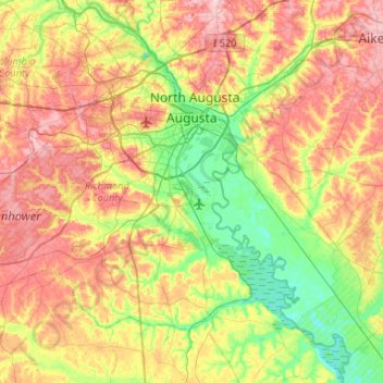
Nom : Carte topographique Augusta, altitude, relief.
Lieu : Augusta, Richmond County, Georgia, United States (33.22717 -82.35387 33.54502 -81.82812)
Altitude moyenne : 89 m
Altitude minimum : 21 m
Altitude maximum : 177 m
As with the rest of the state, Augusta has a humid subtropical climate (Köppen Cfa), with short, mild winters, very hot, humid summers, and a wide diurnal temperature variation throughout much of the year, despite its low elevation and humidity. The monthly daily average temperature ranges from 45.4 °F (7.4 °C) in January to 81.6 °F (27.6 °C) in July; there are 53 nights with the low reaching the freezing mark, 82 days reaching or exceeding 90 °F (32 °C), and 5.5 days reaching 100 °F (38 °C) annually. Extreme temperatures range from −1 °F (−18 °C) on January 21, 1985 up to 108 °F (42 °C) on August 10, 2007, and August 21, 1983. Snowfall is not nearly as common as in Atlanta, due largely to Augusta's elevation, with downtown Augusta being about 900 ft (270 m) lower than downtown Atlanta. The heaviest recorded snowfall was in February 1973 with 14.0″ snowfall (35.56 cm) Freezing rain is also a threat in wintertime.
Autres cartes topographiques
Cliquez sur une carte pour visualiser sa topographie, son altitude et son relief.
Bonair
United States > Georgia > Richmond County > Augusta
Bonair, Augusta, Richmond County, Georgia, 30990, United States
Altitude moyenne : 84 m
Bel Air Heights
United States > Georgia > Richmond County > Augusta
Bel Air Heights, Augusta, Richmond County, Georgia, 30905, United States
Altitude moyenne : 118 m
Blythe
United States > Georgia > Richmond County > Blythe
Blythe, Richmond County, Georgia, 30805, United States
Altitude moyenne : 134 m
Fort Gordon
United States > Georgia > Richmond County > Augusta
Fort Gordon, Augusta, Richmond County, Georgia, 30905, United States
Altitude moyenne : 136 m
Waverly
United States > Georgia > Richmond County > Augusta
Waverly, Augusta, Richmond County, Georgia, 30909, United States
Altitude moyenne : 96 m
Berckman Villas
United States > Georgia > Richmond County > Augusta
Berckman Villas, Augusta, Richmond County, Georgia, 30904, United States
Altitude moyenne : 87 m
Nixon
United States > Georgia > Richmond County > Augusta
Nixon, Augusta, Richmond County, Georgia, United States
Altitude moyenne : 45 m
Marion Homes
United States > Georgia > Richmond County > Augusta
Marion Homes, Augusta, Richmond County, Georgia, 30901, United States
Altitude moyenne : 44 m
Soil Erosion Lake Dam
United States > Georgia > Richmond County > Augusta
Soil Erosion Lake Dam, Augusta, Richmond County, Georgia, 30905, United States
Altitude moyenne : 123 m
Kennelworth
United States > Georgia > Richmond County > Augusta
Kennelworth, Augusta, Richmond County, Georgia, 30909, United States
Altitude moyenne : 87 m
Hephzibah
United States > Georgia > Richmond County
Hephzibah, Richmond County, Georgia, United States
Altitude moyenne : 101 m
Windsor Court
United States > Georgia > Richmond County > Augusta
Windsor Court, Augusta, Richmond County, Georgia, 30904, United States
Altitude moyenne : 66 m
Goshen Plantation
United States > Georgia > Richmond County > Augusta > Goshen Plantation
Goshen Plantation, Augusta, Richmond County, Georgia, United States
Altitude moyenne : 73 m
Ridgewood
United States > Georgia > Richmond County > Augusta > Ridgewood
Ridgewood, Augusta, Richmond County, Georgia, 30909, United States
Altitude moyenne : 103 m