
Carte topographique Roxbury
Carte interactive
Cliquez sur la carte pour afficher l’altitude.
À propos de cette carte
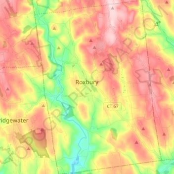
Nom : Carte topographique Roxbury, altitude, relief.
Altitude moyenne : 199 m
Altitude minimum : 59 m
Altitude maximum : 321 m
Autres cartes topographiques
Cliquez sur une carte pour visualiser sa topographie, son altitude et son relief.
Yellow Mountain
United States > Northwest Hills Planning Region > New Hartford
Yellow Mountain, New Hartford, Northwest Hills Planning Region, 06057, United States
Altitude moyenne : 223 m
East Litchfield
United States > Northwest Hills Planning Region > Litchfield
East Litchfield, Litchfield, Northwest Hills Planning Region, 07659, United States
Altitude moyenne : 239 m