
Carte topographique Massachusetts
Carte interactive
Cliquez sur la carte pour afficher l’altitude.
À propos de cette carte
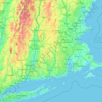
Nom : Carte topographique Massachusetts, altitude, relief.
Lieu : Massachusetts, United States (41.18886 -73.50821 42.88678 -69.86010)
Altitude moyenne : 128 m
Altitude minimum : -7 m
Altitude maximum : 1’159 m
Despite its small size, Massachusetts features numerous topographically distinctive regions. The large coastal plain of the Atlantic Ocean in the eastern section of the state contains Greater Boston, along with most of the state's population, as well as the distinctive Cape Cod peninsula. To the west lies the hilly, rural region of Central Massachusetts, and beyond that, the Connecticut River Valley. Along the western border of Western Massachusetts lies the highest elevated part of the state, the Berkshires, forming a portion of the northern terminus of the Appalachian Mountains.
Autres cartes topographiques
Cliquez sur une carte pour visualiser sa topographie, son altitude et son relief.
Seattle
United States > Washington > King County
Seattle, King County, Washington, United States
Altitude moyenne : 40 m
Phoenix
United States > Arizona > Maricopa County
Phoenix, Maricopa County, Arizona, United States
Altitude moyenne : 481 m
San Francisco
San Francisco, California, United States
Altitude moyenne : 63 m
Chicago
United States > Illinois > Cook County
Chicago, Cook County, Illinois, United States
Altitude moyenne : 182 m
City of Plattsburgh
United States > New York > Clinton County
City of Plattsburgh, Clinton County, New York, United States
Altitude moyenne : 50 m
Austin
United States > Texas > Travis County
Austin, Travis County, Texas, United States
Altitude moyenne : 216 m
Dallas
United States > Texas > Dallas County
Dallas, Dallas County, Texas, United States
Altitude moyenne : 160 m
Portland
United States > Oregon > Multnomah County
Portland, Multnomah County, Oregon, United States
Altitude moyenne : 77 m
Pittsburgh
United States > Pennsylvania > Allegheny County
Pittsburgh, Allegheny County, Pennsylvania, United States
Altitude moyenne : 303 m
San Antonio
United States > Texas > Bexar County
San Antonio, Bexar County, Texas, United States
Altitude moyenne : 247 m
Denver
United States > Colorado > Denver County > Denver
Denver, Denver County, Colorado, United States
Altitude moyenne : 1’684 m
Manhattan
United States > New York > New York County > New York
Manhattan, New York County, New York, United States
Altitude moyenne : 16 m
Houston
United States > Texas > Harris County
Houston, Harris County, Texas, United States
Altitude moyenne : 25 m
Clearwater
United States > Florida > Pinellas County
Clearwater, Pinellas County, Florida, United States
Altitude moyenne : 8 m
Salt Lake City
United States > Utah > Salt Lake County
Salt Lake City, Salt Lake County, Utah, United States
Altitude moyenne : 1’592 m
Saint Petersburg
United States > Florida > Pinellas County
Saint Petersburg, Pinellas County, Florida, United States
Altitude moyenne : 4 m
Boston
United States > Massachusetts > Suffolk County
Boston, Suffolk County, Massachusetts, United States
Altitude moyenne : 25 m
St. Louis
United States > Illinois > Madison County > St. Louis
St. Louis, City of Saint Louis, Madison County, Illinois, United States
Altitude moyenne : 150 m
San Diego
United States > California > San Diego County
San Diego, San Diego County, California, United States
Altitude moyenne : 125 m
Miami
United States > Florida > Miami-Dade County
Miami, Miami-Dade County, Florida, United States
Altitude moyenne : 5 m
Nashville-Davidson
United States > Tennessee > Davidson County
Nashville-Davidson, Davidson County, Middle Tennessee, Tennessee, United States
Altitude moyenne : 184 m
Philadelphia
United States > Pennsylvania > Philadelphia County
Philadelphia, Pennsylvania, United States
Altitude moyenne : 44 m
Cincinnati
United States > Ohio > Hamilton County
Cincinnati, Hamilton County, Ohio, United States
Altitude moyenne : 222 m
Charlotte
United States > North Carolina > Mecklenburg County
Charlotte, Mecklenburg County, North Carolina, United States
Altitude moyenne : 207 m
Columbia
United States > South Carolina > Richland County
Columbia, Richland County, South Carolina, United States
Altitude moyenne : 89 m
El Paso
United States > Texas > El Paso County
El Paso, El Paso County, Texas, United States
Altitude moyenne : 1’237 m
Buffalo
United States > New York > Erie County
Buffalo, Erie County, New York, United States
Altitude moyenne : 185 m
Reno
United States > Nevada > Washoe County
Reno, Washoe County, Nevada, United States
Altitude moyenne : 1’650 m
Detroit
United States > Michigan > Wayne County
Detroit, Wayne County, Michigan, United States
Altitude moyenne : 187 m
Fayetteville
United States > Arkansas > Washington County
Fayetteville, Washington County, Arkansas, United States
Altitude moyenne : 401 m
Cleveland
United States > Ohio > Cuyahoga County
Cleveland, Cuyahoga County, Ohio, United States
Altitude moyenne : 215 m