Géolocaliser

Carte topographique Kullu

Carte interactive

Cliquez sur la carte pour afficher l’altitude.

À propos de cette carte

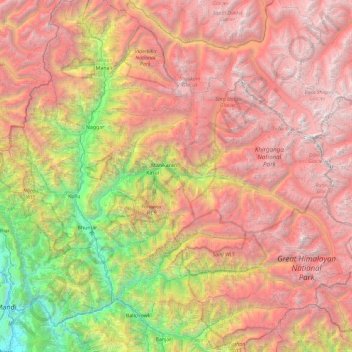
Nom : Carte topographique Kullu, altitude, relief.

Lieu : Kullu, Himachal Pradesh, Inde (31.78141 76.93577 32.22417 77.86770)

Altitude moyenne : 3’631 m

Altitude minimum : 736 m

Altitude maximum : 6’496 m

Autres cartes topographiques

Cliquez sur une carte pour visualiser sa topographie, son altitude et son relief.

Bali Chowki

Inde > Himachal Pradesh

Bali Chowki, Mandi District, Himachal Pradesh, 175106, Inde

Altitude moyenne : 2’289 m

Jannu

Inde > Himachal Pradesh > Theog

Jannu, Theog, Shimla District, Himachal Pradesh, 171209, Inde

Altitude moyenne : 1’836 m

Jia

Inde > Himachal Pradesh > Kullu

Jia, Kullu, Kullu District, Himachal Pradesh, 175126, Inde

Altitude moyenne : 1’378 m

Bhalyani

Inde > Himachal Pradesh > Kullu

Bhalyani, Kullu, Kullu District, Himachal Pradesh, 175102, Inde

Altitude moyenne : 2’050 m

Tosa

Inde > Himachal Pradesh > Chamba

Tosa, Chamba, Chamba district, Himachal Pradesh, 176319, Inde

Altitude moyenne : 1’674 m

Jaun

Inde > Himachal Pradesh > Jogindarnagar

Jaun, Jogindarnagar, Mandi District, Himachal Pradesh, 175014, Inde

Altitude moyenne : 1’120 m