
Carte topographique Lower Garden District
Carte interactive
Cliquez sur la carte pour afficher l’altitude.
À propos de cette carte
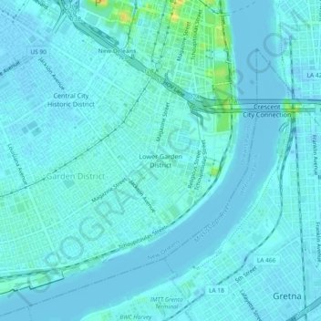
Nom : Carte topographique Lower Garden District, altitude, relief.
Altitude moyenne : 3 m
Altitude minimum : -6 m
Altitude maximum : 27 m
Lower Garden District is located at 29°56′02″N 90°04′12″W / 29.93389°N 90.07000°W / 29.93389; -90.07000 and has an elevation of 6 feet (1.8 m). According to the United States Census Bureau, the district has a total area of 1.16 square miles (3.0 km2), 0.95 square miles (2.5 km2) of which is land and 0.21 square miles (0.5 km2) (18.1%) of which is water.