
Carte topographique Harlan County
Carte interactive
Cliquez sur la carte pour afficher l’altitude.
À propos de cette carte
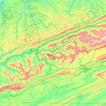
Nom : Carte topographique Harlan County, altitude, relief.
Lieu : Harlan County, Kentucky, United States (36.66475 -83.51180 37.02121 -82.85587)
Altitude moyenne : 560 m
Altitude minimum : 271 m
Altitude maximum : 1’238 m
Black Mountain, located east of Lynch, is Kentucky's highest point, with an elevation of 4,145 feet (1,263 m) above sea level.
Autres cartes topographiques
Cliquez sur une carte pour visualiser sa topographie, son altitude et son relief.
Louisville
United States > Kentucky > Jefferson County
Louisville, Jefferson County, Kentucky, United States
Altitude moyenne : 188 m
Bowling Green
United States > Kentucky > Warren County
Bowling Green, Warren County, Kentucky, 42101, United States
Altitude moyenne : 169 m
Newport
United States > Kentucky > Campbell County
Newport, Campbell County, Kentucky, 41071, United States
Altitude moyenne : 173 m
Paducah
United States > Kentucky > McCracken County
Paducah, McCracken County, Kentucky, United States
Altitude moyenne : 108 m
Somerset
United States > Kentucky > Pulaski County
Somerset, Pulaski County, Kentucky, 42503, United States
Altitude moyenne : 295 m
Pathfork
United States > Kentucky > Harlan County
Pathfork, Harlan County, Kentucky, 40863, United States
Altitude moyenne : 534 m
Lenarue
United States > Kentucky > Harlan County
Lenarue, Harlan County, Kentucky, 40818, United States
Altitude moyenne : 519 m
Sonora
United States > Kentucky > Hardin County
Sonora, Hardin County, Kentucky, United States
Altitude moyenne : 221 m
Load
United States > Kentucky > Greenup County
Load, Greenup County, Kentucky, United States
Altitude moyenne : 222 m
Bardo
United States > Kentucky > Harlan County
Bardo, Harlan County, Kentucky, 40830, United States
Altitude moyenne : 634 m
Putney
United States > Kentucky > Harlan County
Putney, Harlan County, Kentucky, 40865, United States
Altitude moyenne : 601 m
Lone Star
United States > Kentucky > Hart County
Lone Star, Hart County, Kentucky, 42713, United States
Altitude moyenne : 228 m
Owensboro
United States > Kentucky > Daviess County
Owensboro, Daviess County, Kentucky, United States
Altitude moyenne : 123 m
Frankfort
United States > Kentucky > Franklin County
Frankfort, Franklin County, Kentucky, United States
Altitude moyenne : 216 m
Walnut Hill
United States > Kentucky > Fayette County > Lexington
Walnut Hill, Lexington, Fayette County, Kentucky, 40509, United States
Altitude moyenne : 311 m
Hustonville
United States > Kentucky > Lincoln County
Hustonville, Lincoln County, Kentucky, United States
Altitude moyenne : 316 m
Holmes Mill
United States > Kentucky > Harlan County
Holmes Mill, Harlan County, Kentucky, 40843, United States
Altitude moyenne : 758 m
Boyd
United States > Kentucky > Harrison County
Boyd, Harrison County, Kentucky, 41003, United States
Altitude moyenne : 214 m
Hardyville
United States > Kentucky > Hart County
Hardyville, Hart County, Kentucky, United States
Altitude moyenne : 212 m
Uno
United States > Kentucky > Hart County
Uno, Hart County, Kentucky, United States
Altitude moyenne : 201 m
Inez
United States > Kentucky > Martin County
Inez, Martin County, Kentucky, 41224, United States
Altitude moyenne : 253 m
Elkhorn City
United States > Kentucky > Pike County
Elkhorn City, Pike County, Kentucky, United States
Altitude moyenne : 364 m
Paint Lick
United States > Kentucky > Garrard County
Paint Lick, Garrard County, Kentucky, 40461, United States
Altitude moyenne : 272 m
Sparrow
United States > Kentucky > Anderson County
Sparrow, Anderson County, Kentucky, United States
Altitude moyenne : 230 m
Alva
United States > Kentucky > Harlan County
Alva, Harlan County, Kentucky, 40863, United States
Altitude moyenne : 652 m
Pansy
United States > Kentucky > Harlan County
Pansy, Harlan County, Kentucky, 40830, United States
Altitude moyenne : 602 m
Leesburg
United States > Kentucky > Harrison County
Leesburg, Harrison County, Kentucky, United States
Altitude moyenne : 280 m
Frost
United States > Kentucky > Greenup County
Frost, Greenup County, Kentucky, 41175, United States
Altitude moyenne : 180 m
Saint John
United States > Kentucky > Hardin County
Saint John, Hardin County, Kentucky, 42724, United States
Altitude moyenne : 237 m
Nolin
United States > Kentucky > Hardin County
Nolin, Hardin County, Kentucky, 42740, United States
Altitude moyenne : 210 m
Wallins Creek
United States > Kentucky > Harlan County
Wallins Creek, Harlan County, Kentucky, United States
Altitude moyenne : 416 m
Lejunior
United States > Kentucky > Harlan County
Lejunior, Harlan County, Kentucky, 40865, United States
Altitude moyenne : 585 m
Pine Mountain
United States > Kentucky > Harlan County
Pine Mountain, Harlan County, Kentucky, United States
Altitude moyenne : 536 m
Three Point
United States > Kentucky > Harlan County
Three Point, Harlan County, Kentucky, 40815, United States
Altitude moyenne : 475 m
Louellen
United States > Kentucky > Harlan County
Louellen, Harlan County, Kentucky, 40849, United States
Altitude moyenne : 698 m
Jonesville
United States > Kentucky > Hart County
Jonesville, Hart County, Kentucky, 42757, United States
Altitude moyenne : 241 m
Kenvir
United States > Kentucky > Harlan County
Kenvir, Harlan County, Kentucky, 40847, United States
Altitude moyenne : 642 m
Ages
United States > Kentucky > Harlan County
Ages, Harlan County, Kentucky, 40801, United States
Altitude moyenne : 587 m
Fresh Meadows
United States > Kentucky > Harlan County
Fresh Meadows, Harlan County, Kentucky, 40824, United States
Altitude moyenne : 462 m
Yancey
United States > Kentucky > Harlan County
Yancey, Harlan County, Kentucky, 40830, United States
Altitude moyenne : 651 m
Broadwell
United States > Kentucky > Harrison County
Broadwell, Harrison County, Kentucky, United States
Altitude moyenne : 264 m
Wolf
United States > Kentucky > Carter County
Wolf, Carter County, Kentucky, United States
Altitude moyenne : 271 m
Howe Valley
United States > Kentucky > Hardin County
Howe Valley, Hardin County, Kentucky, United States
Altitude moyenne : 221 m
Hardin Springs
United States > Kentucky > Hardin County
Hardin Springs, Hardin County, Kentucky, 40145, United States
Altitude moyenne : 195 m
Hartford
United States > Kentucky > Ohio County
Hartford, Ohio County, Kentucky, United States
Altitude moyenne : 123 m
Limp
United States > Kentucky > Hardin County
Limp, Hardin County, Kentucky, United States
Altitude moyenne : 211 m
Big Laurel
United States > Kentucky > Harlan County
Big Laurel, Harlan County, Kentucky, 40808, United States
Altitude moyenne : 574 m
Cawood
United States > Kentucky > Harlan County
Cawood, Harlan County, Kentucky, 40818, United States
Altitude moyenne : 498 m
White Mills
United States > Kentucky > Hardin County
White Mills, Hardin County, Kentucky, 42788, United States
Altitude moyenne : 195 m