
Carte topographique Minnehaha County
Carte interactive
Cliquez sur la carte pour afficher l’altitude.
À propos de cette carte
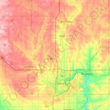
Nom : Carte topographique Minnehaha County, altitude, relief.
Lieu : Minnehaha County, South Dakota, United States (43.49969 -97.12949 43.84949 -96.45313)
Altitude moyenne : 469 m
Altitude minimum : 385 m
Altitude maximum : 553 m
Autres cartes topographiques
Cliquez sur une carte pour visualiser sa topographie, son altitude et son relief.
Mount Rushmore
Mount Rushmore National Memorial is centered on a colossal sculpture carved into the granite face of Mount Rushmore (Lakota Tȟuŋkášila Šákpe, or Six Grandfathers) in the Black Hills in Keystone, South Dakota. Sculptor Gutzon Borglum created the sculpture's design and oversaw the project's execution from…
Altitude moyenne : 1’562 m
Kirby Dog Park at Fort Sod
United States > South Dakota > Minnehaha County > Sioux Falls
Altitude moyenne : 441 m
Brooking Municipal Utilitys
United States > South Dakota > Brookings County > Brookings
Altitude moyenne : 492 m
Sioux Council Boy Scout Reservation
United States > South Dakota > Yankton County
Altitude moyenne : 413 m
North Sioux City
United States > South Dakota > Union County > North Sioux City > North Sioux City
Altitude moyenne : 353 m
Groton City Limit
United States > South Dakota > Brown County > Groton City Limit
Altitude moyenne : 398 m
Vermillion
United States > South Dakota > Clay County > Vermillion
The elevation of the city is 1,221 feet (372 m).
Altitude moyenne : 379 m