
Carte topographique Crowborough
Carte interactive
Cliquez sur la carte pour afficher l’altitude.
À propos de cette carte
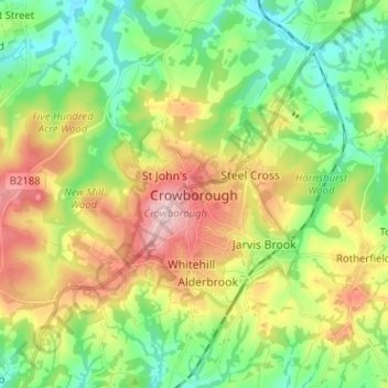
Nom : Carte topographique Crowborough, altitude, relief.
Altitude moyenne : 125 m
Altitude minimum : 48 m
Altitude maximum : 244 m
In the late 19th century Crowborough was promoted as a health resort based on its high elevation, the rolling hills and surrounding forest. Estate Agents even called it "Scotland in Sussex". The town's golf course opened in 1895, followed by a fire station and hospital in 1900.