
Carte topographique Windermere
Carte interactive
Cliquez sur la carte pour afficher l’altitude.
À propos de cette carte
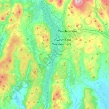
Nom : Carte topographique Windermere, altitude, relief.
Altitude moyenne : 132 m
Altitude minimum : 3 m
Altitude maximum : 478 m
There is debate as to whether the stretch of water between Newby Bridge and Lakeside at the southern end of the lake should be considered part of Windermere, or a navigable stretch of the River Leven. This affects the stated length of the lake, which is 11.23 miles (18.07 km) long if measured from the bridge at Newby Bridge,[10] or 10.5 miles (16.9 km) if measured from Lakeside[citation needed]. The lake varies in width up to a maximum of 1 mile (1.6 km), and covers an area of 14.73 km2 (5.69 sq mi).[10] With a maximum depth of 66.7 m (219 ft) and an elevation above sea level of 39 m (128 ft), the lowest point of the lake bed is well below sea level.[10]
Autres cartes topographiques
Cliquez sur une carte pour visualiser sa topographie, son altitude et son relief.
Storrs
United Kingdom > England > Cumbria > South Lakeland > Bowness-on-Windermere
Storrs, Windermere, Bowness-on-Windermere, South Lakeland, Cumbria, England, LA23 3QR, United Kingdom
Altitude moyenne : 93 m