Géolocaliser

Carte topographique Portsea Island

Carte interactive

Cliquez sur la carte pour afficher l’altitude.

À propos de cette carte

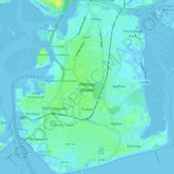
Nom : Carte topographique Portsea Island, altitude, relief.

Lieu : Portsea Island, Portsmouth, England, United Kingdom (50.77761 -1.11176 50.83699 -1.02856)

Altitude moyenne : 3 m

Altitude minimum : -5 m

Altitude maximum : 18 m

Autres cartes topographiques

Cliquez sur une carte pour visualiser sa topographie, son altitude et son relief.

Tipner

United Kingdom > England > Portsmouth

Tipner, Portsmouth, England, PO2 8RD, United Kingdom

Altitude moyenne : 3 m

Portsdown Hill

United Kingdom > England > Portsmouth

Portsdown Hill, Portsdown Hill Road, Wymering, Cosham, Portsmouth, South East, England, PO6 3LS, United Kingdom

Altitude moyenne : 39 m

Bastion 3, Hilsea Lines

United Kingdom > England > Portsmouth

Bastion 3, Hilsea Lines, Scott Road, Hilsea, Portsmouth, England, PO3 5LX, United Kingdom

Altitude moyenne : 4 m

Gobs Barrow

United Kingdom > England > Portsmouth

Gobs Barrow, Portsdown Hill Road, Drayton, Portsmouth, South East England, England, PO6 1BG, United Kingdom

Altitude moyenne : 40 m

Hilsea Lines

United Kingdom > England > Portsmouth > Tipner

Hilsea Lines, Hilsea Crescent, Hilsea, Tipner, Portsmouth, South East, England, PO2 9SN, United Kingdom

Altitude moyenne : 5 m

Victoria Park

United Kingdom > England > Portsmouth

Victoria Park, Stamshaw, Portsea, Portsmouth, South East, England, PO1 3HJ, United Kingdom

Altitude moyenne : 4 m

Fort Cumberland

United Kingdom > England > Portsmouth

Fort Cumberland, Portsmouth, South East, England, PO4 9LD, United Kingdom

Altitude moyenne : 1 m