
Carte topographique Hilpoltstein
Carte interactive
Cliquez sur la carte pour afficher l’altitude.
À propos de cette carte
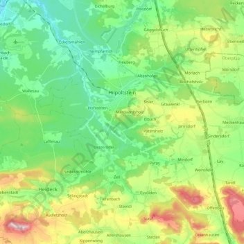
Nom : Carte topographique Hilpoltstein, altitude, relief.
Lieu : Hilpoltstein, Landkreis Roth, Bayern, 91161, Deutschland (49.12640 11.11503 49.21764 11.32773)
Altitude moyenne : 418 m
Altitude minimum : 331 m
Altitude maximum : 600 m
Hilpoltstein entwickelte sich zum Unterzentrum, erfüllt aber viele Funktionen eines Mittelzentrums. Am 2. September 2006 stellte eine Lokomotive vom Typ ES 64 U4 mit 357 km/h einen neuen Geschwindigkeits-Weltrekord für konventionelle Elektrolokomotiven im Gebiet der Stadt Hilpoltstein auf Höhe der Autobahn-Raststätte Hilpoltstein an der Schnellfahrstrecke Nürnberg–Ingolstadt auf.
Autres cartes topographiques
Cliquez sur une carte pour visualiser sa topographie, son altitude et son relief.
Weinsfeld
Deutschland > Bayern > Landkreis Roth > Hilpoltstein
Weinsfeld, Hilpoltstein, Landkreis Roth, Bayern, Deutschland
Altitude moyenne : 442 m
Poppenreuth
Deutschland > Bayern > Landkreis Roth > Kammerstein
Poppenreuth, Kammerstein, Landkreis Roth, Bayern, 91183, Deutschland
Altitude moyenne : 395 m
Wildenbergen
Deutschland > Bayern > Landkreis Roth > Kottensdorf
Wildenbergen, Kottensdorf, Rohr, Landkreis Roth, Bayern, 91189, Deutschland
Altitude moyenne : 380 m
Hagershof
Deutschland > Bayern > Landkreis Roth > Schwanstetten > Mittelhembach
Hagershof, Mittelhembach, Schwanstetten, Landkreis Roth, Bayern, 90596, Deutschland
Altitude moyenne : 342 m
Belmbrach
Deutschland > Bayern > Landkreis Roth > Roth
Belmbrach, Roth, Landkreis Roth, Bayern, 91154, Deutschland
Altitude moyenne : 362 m
Massenberg
Deutschland > Bayern > Landkreis Roth > Spalt
Massenberg, Spalt, Landkreis Roth, Bayern, 91174, Deutschland
Altitude moyenne : 435 m
Kleinabenberg
Deutschland > Bayern > Landkreis Roth > Abenberg
Kleinabenberg, Abenberg, Landkreis Roth, Bayern, 91183, Deutschland
Altitude moyenne : 390 m
Reckenricht
Deutschland > Bayern > Landkreis Roth > Allersberg
Reckenricht, Allersberg, Landkreis Roth, Bayern, 90584, Deutschland
Altitude moyenne : 420 m
Greding
Deutschland > Bayern > Landkreis Roth
Greding, Landkreis Roth, Bayern, 91171, Deutschland
Altitude moyenne : 488 m
Mauk
Deutschland > Bayern > Landkreis Roth
Mauk, Georgensgmünd, Landkreis Roth, Bayern, 91187, Deutschland
Altitude moyenne : 391 m
Igelsdorf
Deutschland > Bayern > Landkreis Roth
Igelsdorf, Rednitzhembach, Landkreis Roth, Bayern, 91186, Deutschland
Altitude moyenne : 343 m
Spalt
Deutschland > Bayern > Landkreis Roth
Spalt, Landkreis Roth, Bayern, 91174, Deutschland
Altitude moyenne : 421 m
Wassermungenau
Deutschland > Bayern > Landkreis Roth > Abenberg
Wassermungenau, Abenberg, Landkreis Roth, Bayern, Deutschland
Altitude moyenne : 400 m
Rothsee (Hauptsperre)
Deutschland > Bayern > Landkreis Roth > Roth > Haimpfarrich
Rothsee (Hauptsperre), Haimpfarrich, Roth, Landkreis Roth, Bayern, Deutschland
Altitude moyenne : 382 m
Kammerstein
Deutschland > Bayern > Landkreis Roth
Kammerstein, Landkreis Roth, Bayern, Deutschland
Altitude moyenne : 383 m
Rednitzhembach
Deutschland > Bayern > Landkreis Roth
Rednitzhembach, Landkreis Roth, Bayern, Deutschland
Altitude moyenne : 347 m
Allersberg
Deutschland > Bayern > Landkreis Roth > Allersberg > Allersberg
Allersberg, Landkreis Roth, Bayern, 90584, Deutschland
Altitude moyenne : 408 m
Thalmässing
Deutschland > Bayern > Landkreis Roth
Thalmässing, Landkreis Roth, Bayern, 91177, Deutschland
Altitude moyenne : 476 m
Rednitzhembach
Deutschland > Bayern > Landkreis Roth > Rednitzhembach > Rednitzhembach
Rednitzhembach, Landkreis Roth, Bayern, 91186, Deutschland
Altitude moyenne : 350 m
Haag
Deutschland > Bayern > Landkreis Roth > Haag
Haag, Kammerstein, Landkreis Roth, Bayern, 91126, Deutschland
Altitude moyenne : 379 m
Rothaurach
Deutschland > Bayern > Landkreis Roth > Roth > Rothaurach
Rothaurach, Roth, Landkreis Roth, Bayern, 91186, Deutschland
Altitude moyenne : 365 m
Petersgmünd
Deutschland > Bayern > Landkreis Roth
Petersgmünd, Georgensgmünd, Landkreis Roth, Bayern, 91166, Deutschland
Altitude moyenne : 368 m
Steinfurt
Deutschland > Bayern > Landkreis Roth > Spalt > Wasserzell > Steinfurt
Steinfurt, Wasserzell, Spalt, Landkreis Roth, Bayern, 91174, Deutschland
Altitude moyenne : 407 m
Schwanstetten
Deutschland > Bayern > Landkreis Roth
Schwanstetten, Landkreis Roth, Bayern, 90596, Deutschland
Altitude moyenne : 352 m
Oberheckenhofen
Deutschland > Bayern > Landkreis Roth > Oberheckenhofen
Oberheckenhofen, Georgensgmünd, Landkreis Roth, Bayern, 91166, Deutschland
Altitude moyenne : 371 m
Allersberg
Deutschland > Bayern > Landkreis Roth
Allersberg, Landkreis Roth, Bayern, 90584, Deutschland
Altitude moyenne : 406 m
Rohr
Deutschland > Bayern > Landkreis Roth > Rohr
Rohr, Landkreis Roth, Bayern, 91189, Deutschland
Altitude moyenne : 399 m
Wendelstein
Deutschland > Bayern > Landkreis Roth
Wendelstein, Landkreis Roth, Bayern, 90530, Deutschland
Altitude moyenne : 355 m
Georgensgmünd
Deutschland > Bayern > Landkreis Roth
Georgensgmünd, Landkreis Roth, Bayern, 91166, Deutschland
Altitude moyenne : 387 m
Büchenbach
Deutschland > Bayern > Landkreis Roth
Büchenbach, Landkreis Roth, Bayern, 91186, Deutschland
Altitude moyenne : 363 m
Mäbenberg
Deutschland > Bayern > Landkreis Roth > Georgensgmünd
Mäbenberg, Georgensgmünd, Landkreis Roth, Bayern, 91166, Deutschland
Altitude moyenne : 399 m
Laibstadt
Deutschland > Bayern > Landkreis Roth > Heideck
Laibstadt, Heideck, Landkreis Roth, Bayern, 91180, Deutschland
Altitude moyenne : 488 m
Heideck
Deutschland > Bayern > Landkreis Roth
Heideck, Landkreis Roth, Bayern, 91180, Deutschland
Altitude moyenne : 441 m
Abenberg
Deutschland > Bayern > Landkreis Roth
Abenberg, Landkreis Roth, Bayern, 91183, Deutschland
Altitude moyenne : 397 m