
Carte topographique Meghalaya
Carte interactive
Cliquez sur la carte pour afficher l’altitude.
À propos de cette carte
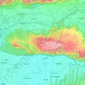
Nom : Carte topographique Meghalaya, altitude, relief.
Lieu : Meghalaya, Inde (25.03065 89.81444 26.11817 92.80274)
Altitude moyenne : 244 m
Altitude minimum : 0 m
Altitude maximum : 2’336 m
Le climat du Meghalaya est modéré mais humide, la moyenne annuelle des précipitations atteignant 12 000 mm (12 mètres) dans certaines zones, ce qui en fait l'État le plus arrosé de la fédération. La ville de Cherrapunji, au sud de la capitale, détient le record mondial des précipitations sur un mois, tandis que le village de Mawsynram, près de Cherrapunji, détient celui du record des précipitations sur une année. Un tiers du Meghalaya est couvert de forêts. La chaîne des Garo à l'Ouest, celle des Khasi et celle des Jaintia à l'Est, sont d'une altitude modérée, le point culminant étant le pic Shillong s'élevant à 1 965 m.
Autres cartes topographiques
Cliquez sur une carte pour visualiser sa topographie, son altitude et son relief.
Bali Chowki
Bali Chowki, Mandi District, Himachal Pradesh, 175106, Inde
Altitude moyenne : 2’289 m
Kala Pipal
Inde > Madhya Pradesh > Kalapipal Tahsil
Kala Pipal, Kalapipal Tahsil, Shajapur District, Madhya Pradesh, 465337, Inde
Altitude moyenne : 481 m
Nanda Devi
Inde > Uttarakhand > Joshimath Tehsil
Nanda Devi, Joshimath Tehsil, Chamoli District, Uttarakhand, Inde
Altitude moyenne : 6’567 m
Jannu
Inde > Himachal Pradesh > Theog
Jannu, Theog, Shimla District, Himachal Pradesh, 171209, Inde
Altitude moyenne : 1’836 m
Parle
Inde > Maharashtra > Chandgad
Parle, Chandgad, Kolhapur, Maharashtra, Inde
Altitude moyenne : 716 m
Chate
Inde > Arunachal Pradesh > Yangte Circle > Kikum
Chate, Kikum, Yangte Circle, Kra Daadi District, Arunachal Pradesh, Inde
Altitude moyenne : 1’053 m
Baltal
Inde > Jammu-et-Cachemire > Kangan
Baltal, Kangan, Ganderbal District, Jammu-et-Cachemire, 191203, Inde
Altitude moyenne : 3’160 m
Amarnath
Inde > Jammu-et-Cachemire > Mandi tehsil
Amarnath, Mandi tehsil, Poonch District, Jammu-et-Cachemire, 185102, Inde
Altitude moyenne : 1’713 m
Jia
Inde > Himachal Pradesh > Kullu
Jia, Kullu, Kullu District, Himachal Pradesh, 175126, Inde
Altitude moyenne : 1’378 m
Fagne
Inde > Maharashtra > Dhule
Fagne, Dhule, Dhule District, Maharashtra, 424301, Inde
Altitude moyenne : 261 m
Bhalyani
Inde > Himachal Pradesh > Kullu
Bhalyani, Kullu, Kullu District, Himachal Pradesh, 175102, Inde
Altitude moyenne : 2’050 m
Chamoli
Inde > Uttarakhand > Chamoli Tehsil
Chamoli, Chamoli Tehsil, Chamoli district, Uttarakhand, 246426, Inde
Altitude moyenne : 1’425 m
Chari
Inde > Uttarakhand > Dwarahat
Chari, Dwarahat, Almora, Uttarakhand, Inde
Altitude moyenne : 1’985 m
Sokra
Inde > Rajasthan > Bali Tehsil > Sokra
Sokra, Bali Tehsil, Pali, Rajasthan, Inde
Altitude moyenne : 310 m
Bangalore
Inde > Karnataka > Bangalore North > Bangalore
Bangalore, Bangalore North, Bangalore Urban, Karnataka, 560001, Inde
Altitude moyenne : 879 m
Jaipur
Inde > Rajasthan > Jaipur Tehsil > Jaipur
Jaipur, Jaipur Municipal Corporation, Jaipur Tehsil, Jaipur, Rajasthan, 302001, Inde
Altitude moyenne : 408 m
Tosa
Inde > Himachal Pradesh > Chamba
Tosa, Chamba, Chamba district, Himachal Pradesh, 176319, Inde
Altitude moyenne : 1’674 m
Jaun
Inde > Himachal Pradesh > Jogindarnagar
Jaun, Jogindarnagar, Mandi District, Himachal Pradesh, 175014, Inde
Altitude moyenne : 1’120 m
Sonagiri
Inde > Madhya Pradesh > Sonagiri
Sonagiri, Datia Tahsil, Datia, Madhya Pradesh, Inde
Altitude moyenne : 216 m
Shatrunjaya Hills
Shatrunjaya Hills, Palitana, Palitana Taluka, Bhavnagar District, Gujarat, 364270, Inde
Altitude moyenne : 132 m
Kolkata
Inde > Bengale-Occidental > Howrah
Kolkata, Howrah, Thakurpukur Maheshtala, Howrah, Bengale-Occidental, 711101, Inde
Altitude moyenne : 5 m
Lat
Inde > Maharashtra > Lat
Lat, Shirol, Kolhapur district, Maharashtra, Inde
Altitude moyenne : 542 m
Ladakh Range
Inde > Jammu-et-Cachemire > Leh
Ladakh Range, Leh, Leh District, Jammu-et-Cachemire, Inde
Altitude moyenne : 4’936 m
Poudouchéry
Inde > Poudouchéry > Taluk de Poudouchéry
Poudouchéry, Taluk de Poudouchéry, District de Poudouchéry, Poudouchéry, 605001, Inde
Altitude moyenne : 10 m
Walunj
Inde > Maharashtra > Walunj
Walunj, Nagar, Ahmednagar, Maharashtra, 414006, Inde
Altitude moyenne : 632 m
Malleswaram
Malleswaram, West Zone, Bangalore, Bangalore Urban, Karnataka, 560055, Inde
Altitude moyenne : 925 m
Sokhda Village
Inde > Gujarat > Sokhda Village
Sokhda Village, Vadodara Taluka, Vadodara District, Gujarat, 390025, Inde
Altitude moyenne : 43 m
Thiruvananthapuram
Inde > Kerala > Thiruvananthapuram
Thiruvananthapuram, Kerala, 695001, Inde
Altitude moyenne : 38 m