
Carte topographique Qeqertarsuaq
Carte interactive
Cliquez sur la carte pour afficher l’altitude.
À propos de cette carte
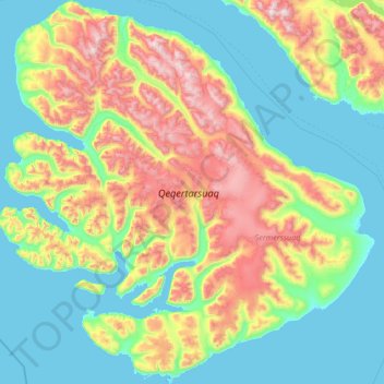
Nom : Carte topographique Qeqertarsuaq, altitude, relief.
Lieu : Qeqertarsuaq, Qeqertalik, Groenland (69.23089 -54.97604 70.33043 -51.84955)
Altitude moyenne : 424 m
Altitude minimum : -3 m
Altitude maximum : 1’943 m
Autres cartes topographiques
Cliquez sur une carte pour visualiser sa topographie, son altitude et son relief.