
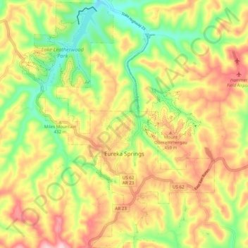
Carte topographique Eureka Springs
Carte interactive
Cliquez sur la carte pour afficher l’altitude.
À propos de cette carte
Nom : Carte topographique Eureka Springs, altitude, relief.
Altitude moyenne : 411 m
Altitude minimum : 300 m
Altitude maximum : 525 m
It is a tourist destination for its unique character as a Victorian resort, which first attracted visitors to use its then believed healing springs. The city has steep winding streets filled with Victorian-style cottages and manors. The historic commercial downtown of the city has an extensive streetscape of well-preserved Victorian buildings. The buildings are primarily constructed of local stone, built along limestone streets that curve around the hills, and rise and fall with the topography in a five-mile long loop. Some buildings have street-level entrances on more than one floor and other such oddities: the Basin Park Hotel has its front entrances on the floor below first, and a ground-level emergency exit in the back of the building on the fifth floor. The streets wind around the town, with few intersecting at right angles. There are no traffic lights.
Autres cartes topographiques
Cliquez sur une carte pour visualiser sa topographie, son altitude et son relief.
Rule
United States > Arkansas > Carroll County
Rule, Carroll County, Arkansas, United States
Altitude moyenne : 432 m
Urbanette
United States > Arkansas > Carroll County
Urbanette, Carroll County, Arkansas, United States
Altitude moyenne : 382 m
Blue Eye, AR
United States > Arkansas > Carroll County
Blue Eye, AR, Carroll County, Arkansas, United States
Altitude moyenne : 381 m
Oak Grove
United States > Arkansas > Carroll County
Oak Grove, Carroll County, Arkansas, 72616, United States
Altitude moyenne : 390 m
Beaver
United States > Arkansas > Carroll County
Beaver, Carroll County, Arkansas, 72613, United States
Altitude moyenne : 314 m
Eureka Springs
United States > Arkansas > Carroll County > Eureka Springs
Eureka Springs, Carroll County, Arkansas, 72632, United States
Altitude moyenne : 417 m
Maple
United States > Arkansas > Carroll County > Maple
Maple, Carroll County, Arkansas, United States
Altitude moyenne : 394 m
Holiday Island
United States > Arkansas > Carroll County
Holiday Island, Carroll County, Arkansas, 72613, United States
Altitude moyenne : 362 m
Green Forest
United States > Arkansas > Carroll County
Green Forest, Carroll County, Arkansas, 72638, United States
Altitude moyenne : 412 m
Coin
United States > Arkansas > Carroll County > Coin
Coin, Carroll County, Arkansas, United States
Altitude moyenne : 368 m
Berryville
United States > Arkansas > Carroll County
Berryville, Carroll County, Arkansas, 72616, United States
Altitude moyenne : 378 m