Géolocaliser

Carte topographique Deadwood

Cliquez sur la carte pour afficher l’altitude.

Deadwood

Deadwood is characterized by its rugged terrain nestled within the Black Hills region, boasting an elevation of approximately 4,531 feet. The town itself is set in a steep, narrow gulch surrounded by densely forested hills, which create a dramatic landscape of rolling hills and rocky outcrops. The topography features a mix of steep inclines and valleys, making it an ideal setting for outdoor activities like hiking and wildlife observation. The surrounding area is rich in natural beauty, with various trails that weave through the Black Hills National Forest, showcasing diverse flora and fauna, including deer and bighorn sheep​. This unique geography not only contributes to the town's charm but also plays a significant role in its historical development during the Gold Rush era.

À propos de cette carte
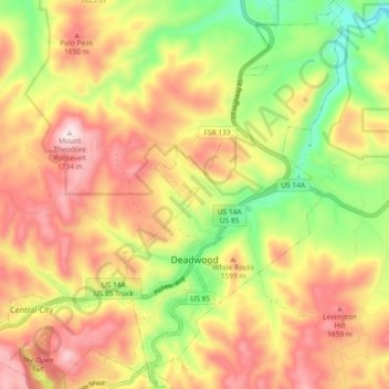
Nom : Carte topographique Deadwood, altitude, relief.

Lieu : Deadwood, Lawrence County, South Dakota, 57732, United States (44.35470 -103.75626 44.42060 -103.69443)

Altitude moyenne : 1’511 m

Altitude minimum : 1’265 m

Altitude maximum : 1’735 m

Autres cartes topographiques

Cliquez sur une carte pour visualiser sa topographie, son altitude et son relief.
Nemo

United States > South Dakota > Lawrence County

Altitude moyenne : 1’490 m

Trojan

United States > South Dakota > Lawrence County

Altitude moyenne : 1’880 m

Kirk

United States > South Dakota > Lawrence County

Altitude moyenne : 1’713 m

Nahant

United States > South Dakota > Lawrence County

Altitude moyenne : 1’806 m

Terry Peak

United States > South Dakota > Lawrence County

Altitude moyenne : 1’940 m

Merritt

United States > South Dakota > Lawrence County

Altitude moyenne : 1’601 m

Spearfish

United States > South Dakota > Lawrence County > Spearfish

Altitude moyenne : 1’291 m

Équipez-vous pour votre prochaine aventure :

🦯Bâtons de marche - Réduisez la fatigue musculaire lors des fortes pentes et descentes
🧦Chaussettes de randonnée - Conception technique pour éviter les ampoules sur les longs dénivelés
💧Poche à eau pour sac - Hydratez-vous facilement sans vous arrêter de marcher
🧢Bonnets en laine mérinos - Chaleur naturelle
🧭Boussoles d’orientation - Boussoles fiables pour navigation terrestre et lecture de cartes

En tant que Partenaire Amazon, ce site perçoit une commission sur les achats éligibles sans surcoût pour vous.